| Gunnerside | |
|---|---|
) Gunnerside Location within North Yorkshire | |
| OS grid reference | SD951982 |
| • London | 210 mi (340 km) SE |
| Civil parish |
|
| District | |
| Shire county | |
| Region | |
| Country | England |
| Sovereign state | United Kingdom |
| Post town | DARLINGTON |
| Postcode district | DL11 |
| Dialling code | 01748 |
| Police | North Yorkshire |
| Fire | North Yorkshire |
| Ambulance | Yorkshire |
| UK Parliament | |
Gunnerside is a village in the Richmondshire district of North Yorkshire, England. It is situated on the B6270 road, 3 miles east of Muker and 6 miles west of Reeth. The village lies between the River Swale and its tributary, Gunnerside Beck, in the Swaledale part of the Yorkshire Dales National Park. The name of the village derives from an Old Norse personal name Gunnar and sætr meaning hill or pasture.[1][2]
Gunnerside Ghyll (or Gunnerside Gill), a smaller valley running northwards, at right angles to the Swale valley (Swaledale), was the site of a major lead mining industry in Swaledale until the late nineteenth century.
Gunnerside contains a Methodist Chapel, a part-time post office, and a working smithy/museum. The village primary school is one of two sites of the Reeth and Gunnerside Schools.[3] At the foot of Gunnerside Ghyll is the Kings Head public house. At the south of the village is the Grade II listed 1830s Gunnerside New Bridge over the River Swale.[4]
Local employment centres on clockmaking, hill farming, gamekeeping and construction, the latter concerned chiefly with the maintenance of traditional stone-built field walls, houses and barns.
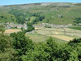
Looking north to Gunnerside
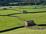
Stone barns in the meadows near Gunnerside New Bridge

Methodist Church
)
)
)
See also
- Operation Gunnerside, which may have got its name because the participants trained on a moor near to Gunnerside owned by Charles Hambro.[5]
References
- ^ Fleming, Andrew (1999). "3;Small-scale communities and the landscape of Swaledale". In Ucko, Peter; Layton, Robert (eds.). The archaeology and anthropology of landscape : shaping your landscape (1 ed.). London: Routledge. p. 69. ISBN 9780415117678.
- ^ Ekwall, Eilert (1960). The concise Oxford dictionary of English place-names (4 ed.). Oxford: Clarendon Press. p. 399. ISBN 0-19-869103-3.
- ^ Philby, Charlotte (19 September 2009). "The lost villages of Britain: Can our rural communities survive in the 21st century?". The Independent. Retrieved 9 October 2017.
- ^ Historic England. "Gunnerside New Bridge (Grade II) (1179749)". National Heritage List for England. Retrieved 3 January 2014.
- ^ "Knut Haugland". The Telegraph. 28 December 2009. Retrieved 9 October 2017.
External links
![]() Media related to Gunnerside at Wikimedia Commons
Media related to Gunnerside at Wikimedia Commons