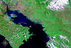
Gulf of Nicoya seen from space (false color)
The Gulf of Nicoya (Spanish: Golfo de Nicoya) is an inlet of the Pacific Ocean. It separates the Nicoya Peninsula from the mainland of Costa Rica, and encompasses a marine and coastal landscape of wetlands, rocky islands and cliffs.
The first Spanish landing in Nicaragua took place here in 1519.[1]
Islands
- Chira Island
- Venado Island
- Isla Caballo
- Isla Bejuco
- Isla San Lucas
- Isla Gitana
- Tortuga Island, Costa Rica

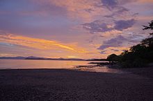
Sunset over the Nicoya Peninsula and Gulf of Nicoya
References
External links
This article is copied from an
article on Wikipedia® - the free encyclopedia created and edited by its online user community. The text was not checked or edited by anyone on our staff. Although the vast majority of Wikipedia® encyclopedia articles provide accurate and timely information, please do not assume the accuracy of any particular article. This article is distributed under the terms of
GNU Free Documentation License.
All content on this website, including dictionary, thesaurus, literature, geography, and other reference data is for informational purposes only. This information should not be considered complete, up to date, and is not intended to be used in place of a visit, consultation, or advice of a legal, medical, or any other professional.

