Wikipedia

Gosen-Neu Zittau

Gosen-Neu Zittau
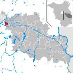
Location of Gosen-Neu Zittau within Oder-Spree district
Gosen-Neu Zittau in LOS.PNG
Gosen-Neu Zittau is located in Germany
Gosen-Neu Zittau
Gosen-Neu Zittau
Gosen-Neu Zittau is located in Brandenburg
Gosen-Neu Zittau
Gosen-Neu Zittau
Coordinates: 52°23′36″N 13°42′46″E / 52.39333°N 13.71278°E
CountryGermany
StateBrandenburg
DistrictOder-Spree
Municipal assoc.Spreenhagen
Subdivisions4 districts
Government
 • MayorHorst Buch (SPD)
Area
 • Total15.07 km2 (5.82 sq mi)
Elevation
37 m (121 ft)
Population
(2019-12-31)[1]
 • Total3,239
 • Density210/km2 (560/sq mi)
Time zoneUTC+01:00 (CET)
 • Summer (DST)UTC+02:00 (CEST)
Postal codes
15537
Dialling codes03362
Vehicle registrationLOS
Websitewww.amt-spreenhagen.de

Gosen-Neu Zittau is a municipality in the Oder-Spree district, in Brandenburg, Germany. Neu Zittau is situated in the Spree valley, near the Oder-Spree-Canal.

Geography

Neighbouring places

Division of the town

  • Gosen
  • Neu Zittau
  • Burig
  • Steinfurt

Demography

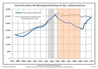
Development of population since 1875 within the current boundaries (Blue line: Population; Dotted line: Comparison to population development of Brandenburg state; Grey background: Time of Nazi rule; Red background: Time of communist rule)
Gosen-Neu Zittau: Population development
within the current boundaries (2013)[2]
YearPop.±% p.a.
1875 1,672—    
1890 1,573−0.41%
1910 2,109+1.48%
1925 2,279+0.52%
1933 2,667+1.98%
1939 2,851+1.12%
1946 3,074+1.08%
1950 2,873−1.68%
1964 2,522−0.93%
1971 2,536+0.08%
1981 2,311−0.92%
1985 2,203−1.19%
1989 2,192−0.13%
1990 2,123−3.15%
1991 2,100−1.08%
1992 2,133+1.57%
1993 2,093−1.88%
1994 2,095+0.10%
1995 2,106+0.53%
1996 2,217+5.27%
YearPop.±% p.a.
1997 2,366+6.72%
1998 2,480+4.82%
1999 2,502+0.89%
2000 2,455−1.88%
2001 2,543+3.58%
2002 2,634+3.58%
2003 2,688+2.05%
2004 2,726+1.41%
2005 2,731+0.18%
2006 2,764+1.21%
2007 2,797+1.19%
2008 2,880+2.97%
2009 2,888+0.28%
2010 2,900+0.42%
2011 3,020+4.14%
2012 2,991−0.96%
2013 3,002+0.37%
2014 2,970−1.07%
2015 3,055+2.86%
2016 3,072+0.56%

References

  1. ^ "Bevölkerung im Land Brandenburg nach amtsfreien Gemeinden, Ämtern und Gemeinden 31. Dezember 2019". Amt für Statistik Berlin-Brandenburg (in German). July 2020.
  2. ^ Detailed data sources are to be found in the Wikimedia Commons.Population Projection Brandenburg at Wikimedia Commons
This article is copied from an article on Wikipedia® - the free encyclopedia created and edited by its online user community. The text was not checked or edited by anyone on our staff. Although the vast majority of Wikipedia® encyclopedia articles provide accurate and timely information, please do not assume the accuracy of any particular article. This article is distributed under the terms of GNU Free Documentation License.

Copyright © 2003-2025 Farlex, Inc Disclaimer
All content on this website, including dictionary, thesaurus, literature, geography, and other reference data is for informational purposes only. This information should not be considered complete, up to date, and is not intended to be used in place of a visit, consultation, or advice of a legal, medical, or any other professional.