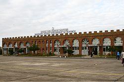
Gondar Atse Tewodros Airport የጎንደር ዓፄ ቴዎድሮስ የአየር ማረፊያ | |||||||||||
|---|---|---|---|---|---|---|---|---|---|---|---|
 | |||||||||||
| Summary | |||||||||||
| Airport type | Public | ||||||||||
| Operator | Ethiopian Airports Enterprise | ||||||||||
| Serves | Gondar, Ethiopia | ||||||||||
| Elevation AMSL | 1,994 m / 6,542 ft | ||||||||||
| Coordinates | 12°31′11″N 037°26′02″E / 12.51972°N 37.43389°E | ||||||||||
| Map | |||||||||||
| Runways | |||||||||||
| |||||||||||
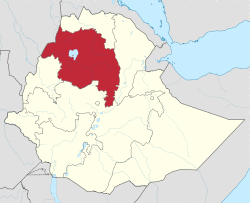
Gondar Airport (IATA: GDQ, ICAO: HAGN), also known as Atse Tewodros Airport,[1] is an airport serving Gondar,[2] a city in the northern Amhara Region of Ethiopia. The name of the city and airport may also be transliterated as Gonder.[3] The airport is located 18 km (11 miles) south of Gondar.[1] The airport is named after the Emperor of Ethiopia (Atse) Tewodros II.[1]
Facilities
Gondar airport resides at an elevation of 1,994 metres (6,542 ft) above mean sea level. It has one runway designated 17/35, with an asphalt surface measuring 2,700 by 45 metres (8,858 ft × 148 ft).[1]
Airlines and destinations
| Airlines | Destinations |
|---|---|
| Ethiopian Airlines[4] | Addis Ababa, Axum, Lalibela |
References
- ^ a b c d e "Gondar Atse Tewodros Airport". Ethiopian Airports Enterprise. Archived from the original on 18 August 2012.
- ^ a b Airport information for HAGN from DAFIF (effective October 2006)
- ^ a b Airport information for GDQ at Great Circle Mapper. Source: DAFIF (effective October 2006).
- ^ "Domestic Route Map". Ethiopian Airlines. Archived from the original on 2011-09-30. Retrieved 2009-07-31.
