| State Route 72 | ||||
|---|---|---|---|---|
 | ||||
| Route information | ||||
| Maintained by GDOT | ||||
| Length | 46.7 mi[1] (75.2 km) | |||
| Major junctions | ||||
| West end | ||||
| East end | ||||
| Location | ||||
| Counties | Clarke, Madison, Elbert | |||
| Highway system | ||||
| ||||
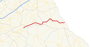
State Route 72 (SR 72) is a 46.7-mile-long (75.2 km) state highway that runs west-to-east through portions of Clarke, Madison, and Elbert counties in the northeastern part of the U.S. state of Georgia. The route connects the Athens area with the South Carolina state line, southwest of Calhoun Falls, South Carolina, via Comer and Elberton.
Route description
SR 72 begins at an intersection with US 29/SR 8 (Old Monroe Road) in the northeastern part of Athens, on the northern edge of Athens Technical College, in Clarke County. It travels to the northeast, crossing into Madison County and passes through the towns of Hull and Colbert, and meets the western terminus of SR 172, just northeast of Colbert. Just before entering Comer, the route crosses over the South Fork Broad River. In town, it intersects the eastern terminus of SR 98 (Gholston Street) and the northern terminus of SR 22 (Main Street). SR 72 departs Comer, passing northeast of Watson Mill Bridge State Park, before crossing through Carlton. It heads northeast, crossing over the Broad River into Elbert County. It continues northeast toward Elberton. Just before entering town, it begins a concurrency with SR 17 (Bowman Highway). In town, it intersects SR 77 (Oliver Street). On the southeastern edge of town, SR 17 splits off to the southeast onto Elbert Street, while SR 72 heads east-southeast. It passes through rural areas of the county, and intersects the northern terminus of SR 79 (Lincolnton Highway), and meets its eastern terminus. At the South Carolina line, it crosses over Richard B. Russell Lake. There, the roadway continues to the northwest, toward Calhoun Falls, as South Carolina Highway 72.[1]
The entire length of SR 72 is part of the National Highway System, a system of routes determined to be the most important for the nation's economy, mobility, and defense.[2][3]
Major intersections

| County | Location | mi[1] | km | Destinations | Notes |
|---|---|---|---|---|---|
| Clarke | Athens | 0.0 | 0.0 | Western terminus | |
| Madison | | 9.5 | 15.3 | Western terminus of SR 172 | |
| | 11.6 | 18.7 | South Fork Broad River | ||
| Comer | 13.3 | 21.4 | Eastern terminus of SR 98 | ||
| 13.4 | 21.6 | Northern terminus of SR 22 | |||
| Broad River | 22.0 | 35.4 | Madison–Elbert county line | ||
| Elbert | | 30.2 | 48.6 | Western end of SR 17 concurrency | |
| Elberton | 31.6 | 50.9 | |||
| Southern terminus of SR 77 Conn.; truck route to SR 77 | |||||
| 33.6 | 54.1 | Eastern end of SR 17 concurrency | |||
| | 42.1 | 67.8 | Northern terminus of SR 79 | ||
| Richard B. Russell Lake | 46.73 | 75.20 | South Carolina state line | ||
| Continuation beyond South Carolina state line | |||||
1.000 mi = 1.609 km; 1.000 km = 0.621 mi
| |||||
References
- ^ a b c Google (July 28, 2013). "Route of SR 72" (Map). Google Maps. Google. Retrieved July 28, 2013.
- ^ National Highway System: Athens-Clarke County, GA (PDF) (Map). Federal Highway Administration. May 9, 2019. Retrieved November 5, 2019.
- ^ National Highway System: Georgia (PDF) (Map). Federal Highway Administration. May 8, 2019. Retrieved November 5, 2019.
External links
