| Browns Peak | |
|---|---|
| Yavapai: Wikopa | |
) View of Four Peaks with some snow | |
| Highest point | |
| Elevation | 7,659 ft (2,334 m) NAVD 88[1] |
| Prominence | 3,297 ft (1,005 m) [2] |
| Listing | Arizona county high point[3] |
| Coordinates | 33°41′04″N 111°19′32″W / 33.684357033°N 111.325686994°W [1] |
| Geography | |
) Browns Peak | |
| Location | Gila/Maricopa counties, Arizona, U.S. |
| Parent range | Mazatzal Mountains |
| Topo map | USGS Four Peaks |
| Climbing | |
| Easiest route | Scramble, class 3 |
Four Peaks (Yavapai: Wi:khoba[4]) is a prominent landmark on the eastern skyline of Phoenix. Part of the Mazatzal Mountains, it is located in the Four Peaks Wilderness [5] in the Tonto National Forest, 40 miles (64 km) east-northeast of Phoenix. In winter, Four Peaks offers much of the Phoenix metro area a view of snow-covered peaks. Four Peaks is the site of an amethyst mine that produces top-grade amethyst.
The name Four Peaks is a reference to the four distinct peaks of a north–south ridge forming the massif's summit. The northernmost peak is named Brown's Peak and is the tallest of the four at 7,659 feet (2,334 m).[1] It is the highest point in Maricopa County. The remaining summits 7,644 feet (2,330 m),[6] 7,574 feet (2,309 m)[7] and 7,526 feet (2,294 m)[8] in elevation.
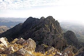
View of other three peaks from Browns Peak
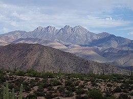
View from desert floor of Four Peaks
)
)
Four Peaks Wilderness
The Four Peaks Wilderness, established in the year 1984, covers 60,740 acres of land. It is home to a diverse variety of plants and animals due to the quick change of elevation in the range.[9] Brown's Trail, found in the Four Peaks Wilderness, is used to reach the tallest peak and is home to black bears, ring-tailed cats, skunks, and coyotes.[10] The Four Peaks Wilderness contains a section of the Arizona Trail, [11] which is considered one of the most difficult passages, as it is infrequently maintained.[12] On April 27th, 1996, a party of two campers left a campfire unattended near Lone Pine Saddle. This caused the Lone Fire which burned over 61,000 acres and lasted 11 days.[13] The Lone fire was Arizona's largest recorded wildfire prior to the Rodeo–Chediski Fire in 2002.
References
- ^ a b c "Four Peaks". NGS data sheet. U.S. National Geodetic Survey. Retrieved 2014-02-04.
- ^ "Browns Peak". Peakbagger.com. Retrieved 2014-02-04.
- ^ "Arizona County High Points". Peakbagger.com. Retrieved 2016-08-16.
- ^ Alan William Shaterian (1983), Phonology and Dictionary of Yavapai, University of California, Berkeley
- ^ "Four Peaks Wilderness". Wilderness.net. Retrieved 2014-02-04.
- ^ "Four Brother Peak, Arizona". Peakbagger.com. Retrieved 2014-02-04.
- ^ "Sister Peak, Arizona". Peakbagger.com. Retrieved 2014-02-04.
- ^ "Amethyst Peak, Arizona". Peakbagger.com. Retrieved 2014-02-04.
- ^ "Four Peaks Wilderness Area". USDA. Retrieved 13 November 2018.
- ^ Allen, Natalie. "Hike Brown's Peak". Arizona Hikers Guide. Retrieved 12 December 2018.
- ^ "Passage 20: Four Peaks". Passage 20 on the AZ Trail. Retrieved 12 December 2018.
- ^ Drown, Jule. "The Arizona Trail". Horse&Rider. Retrieved 12 December 2018.
- ^ "The Lone Fire". USDA. Retrieved 13 November 2018.