| |
|---|---|
) | |
) E40 interchange near Bruges, Belgium | |
| Route information | |
| Length | 8,641 km (5,369 mi) |
| Major junctions | |
| West end | |
| |
| East end | Ridder, Kazakhstan |
| Location | |
| Countries | France, Belgium, Germany, Poland, Ukraine, Russia, Kazakhstan, Uzbekistan, Turkmenistan, Kyrgyzstan |
| Highway system | |
| International E-road network | |
)
)
E 40 roadsign in Skołoszów, Poland
European route E 40 is the longest European route,[1] more than 8,000 kilometres (4,971 miles) long, connecting Calais in France via Belgium, Germany, Poland, Ukraine, Russia, Kazakhstan, Uzbekistan, Turkmenistan, and Kyrgyzstan, with Ridder in Kazakhstan near the border with Russia and China.
Route
 France
 .svg.png) Belgium
Belgium  Germany
  A44: Aachen (E 314)
 A4: Aachen (E 314) - Köln (E 31 / E 35, Towards E 29 / E 37) - Olpe (E 41)
 A45: Olpe (start of concurrency with E 41) - Siegen - Gießen (E 44, end of concurrency with E 41)
 B49: Gießen (E 41 / E 44)
 B429: Gießen
 A480: Gießen (E 451)
 A5: Gießen (E 451) - Bad Hersfeld (E 45)
 A7: Bad Hersfeld (E 45)
- A4: Bad Hersfeld (E 45) - Eisenach - Erfurt - Zwickau (E 49 / E 51 / E 40) - Chemnitz (E 441) - Dresden (E 55) - Görlitz
 Poland
  Ukraine[a]
  Russia
  Kazakhstan
  Uzbekistan
 - Karakalpakstan - Qo'ng'irot - Nukus
 Turkmenistan
 - Konye-Urgench - Daşoguz (
 E003)
E003)
- Konye-Urgench - Daşoguz (
- Uzbekistan
- Kazakhstan
 Kyrgyzstan
  M39: Chaldavar - Kara-Balta (
 E010) - Bishkek (Start of Concurrency with
  E125) - Konstantinovka
- Kazakhstan
 A2: Korday - Almaty (E012, end of concurrency with E125)
 A3: Almaty (E125 / E012) - Sary-Ozek (E013) - Taldykorgan - Usharal (E014) - Ayagoz - Qalbatau (E127) - Öskemen
 A350: Öskemen - Sekisovka
 A10: Sekisovka - Ridder
The road makes a big detour in Central Asia. The shortest road between Calais and Ridder is about 2,000 kilometres (1,243 miles) shorter, mostly using the E30 via Berlin-Moscow-Omsk.
Gallery
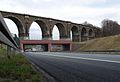
Crossing a railway at Chemnitz in eastern Germany
.jpg)
at Zabrze in Upper Silesian Industrial Region in Poland

E 40 road on Ukrainian highway Kyiv-Zytomyr
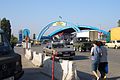
On Kazakh-Kyrgyz border at Korday
)
)
.jpg'))
)
)
)
Notes
References
- ^ Antill, Peter; Dennis, Peter (2007). Stalingrad 1942. Osprey Publishing. ISBN 1-84603-028-5.