Ergny | |
|---|---|
) The church of Ergny | |
) Coat of arms | |
Location of Ergny 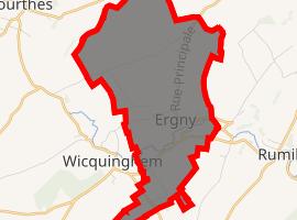 | |
) Ergny ) Ergny | |
| Coordinates: 50°35′03″N 1°58′54″E / 50.5842°N 1.9817°E | |
| Country | France |
| Region | Hauts-de-France |
| Department | Pas-de-Calais |
| Arrondissement | Montreuil |
| Canton | Lumbres |
| Intercommunality | CC Haut Pays du Montreuillois |
| Government | |
| • Mayor (2020–2026) | Bruno Carlu |
| Area 1 | 9.29 km2 (3.59 sq mi) |
| Population (Jan. 2017)[1] | 233 |
| • Density | 25/km2 (65/sq mi) |
| Time zone | UTC+01:00 (CET) |
| • Summer (DST) | UTC+02:00 (CEST) |
| INSEE/Postal code | 62302 /62650 |
| Elevation | 101–166 m (331–545 ft) (avg. 113 m or 371 ft) |
| 1 French Land Register data, which excludes lakes, ponds, glaciers > 1 km2 (0.386 sq mi or 247 acres) and river estuaries. | |
Ergny is a commune in the Pas-de-Calais department in the Hauts-de-France region of France.
Geography
A village situated some 14 miles (22 km) northeast of Montreuil-sur-Mer at the D131E3 road.
Population
| Year | 1962 | 1968 | 1975 | 1982 | 1990 | 1999 |
|---|---|---|---|---|---|---|
| Population | 240 | 250 | 241 | 199 | 186 | 173 |
| From the year 1962 on: No double counting—residents of multiple communes (e.g. students and military personnel) are counted only once. | ||||||
Places of interest
- The fifteenth century church of Saint Leger
See also
References
- ^ "Populations légales 2017". INSEE. Retrieved 6 January 2020.
External links
- Ergny on the Quid website (in French)