| Diran | |
|---|---|
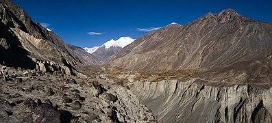
) Diran Peak from Rakaposhi Base Camp | |
| Highest point | |
| Elevation | 7,266 m (23,839 ft) [1] Ranked 93rd |
| Prominence | 1,325 m (4,347 ft) [1] |
| Coordinates | 36°07′N 74°40′E / 36.117°N 74.667°E [1] |
| Naming | |
| Native name | دیرن |
| Geography | |
) Diran Location in Gilgit-Baltistan ) Diran Diran (Gilgit Baltistan) | |
| Location | Gilgit-Baltistan, Pakistan |
| Parent range | Karakoram |
| Climbing | |
| First ascent | 1968 by Rainer Goschl, Rudolph Pischinger and Hanns Schell |
| Easiest route | Rock/snow/ice climb |
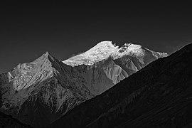
Diran (Urdu: دیرن) is a mountain in the Karakoram range in Nagar Valley and Bagrot Valley Gilgit-Baltistan, Pakistan. This 7,266-metre (23,839 ft) pyramid shaped mountain lies to the east of Rakaposhi (7,788m).
Diran is the most dangerous mountain in Pakistan as its snow is the cause of many events resulting in hundreds of deaths.
Diran was first climbed in 1968 by three Austrians: Rainer Goeschl, Rudolph Pischinger and Hanns Schell. Earlier attempts by a German expedition in 1959 and an Austrian expedition in 1964 were unsuccessful.[2][3]
)
Reflection of Diran (left, 7,266m) and Rakaposhi (right, 7,788m, peak not visible) from Tagafari base camp
See also
)
)
Gallery
night view of diran peak bagrote valley gilgit
)
)
)
snow caped diran peak bagrote valley gilgit
)
Charming view with Bagrote Sarai Hotel and Resturent Gilgit (diran view Resort Gilgit pakistan )
References
- ^ a b c "Diran". Peakbagger.com. Retrieved 2 October 2011.
- ^ "The Mountains of Pakistan: Diran Peak". EverestNews.com. Retrieved 2 October 2011.
- ^ http://publications.americanalpineclub.org/articles/12196547601/Asia-Pakistan-Minapin-or-Diran