Cuminestown
| |
|---|---|
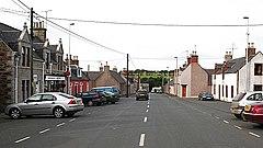
 The square and the main street in Cuminestown | |
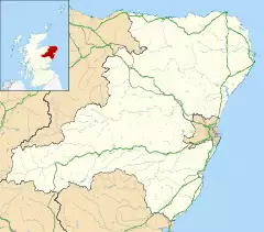
Location within Aberdeenshire | |
| Population | 540 (2012)[1] |
| OS grid reference | NJ802502 |
| Council area | |
| Lieutenancy area | |
| Country | Scotland |
| Sovereign state | United Kingdom |
| Postcode district | AB53 |
| Dialling code | 01888 |
| Police | Scotland |
| Fire | Scottish |
| Ambulance | Scottish |
| UK Parliament | |
| Scottish Parliament |
|
Cuminestown is a village in the Formartine area of Aberdeenshire, and sits at the centre of the parish of Monquhitter. The village of Cuminestown is approximately 6 miles from Turriff and New Deer, 10 miles from Macduff and Banff and 15 miles from Fraserburgh. Monquhitter is a small rural parish nestling in the heart of Aberdeenshire. Although it is not a large community, it has much to offer both in terms of local amenities and beautiful rural landscapes. It also incorporates the small village of Garmond and many houses and farms in the surrounding areas including Greeness and Greens. The parish was split from Turriff in 1649 when what was then a rural church was built on land owned by the Cumine family. The village itself was originally built in the 1750s to a design by Sir Archibald Grant of Monymusk, who was a friend of Joseph Cumine. Grant's plan for the village followed closely the design used for firstly New Keith, and secondly Archiestown. The construction of the village was followed soon afterwards by the adjacent hamlet of Garmond.
The postcode of Cuminestown is within the Turriff and District ward/electoral division, which is in the UK Parliamentary Constituency of Banff and Buchan. The Scottish Parliament constituency is Aberdeenshire East.
In 2011, Cuminestown had an estimated population of 440.[2] It is currently estimated to have a population of 540
The village primary school, called Monquhitter School, also serves Garmond and New Byth.
See also
- List of listed buildings in Monquhitter, Aberdeenshire
References
- ^ Estimated population of settlements by broad age groups, mid-2012 nrscotland.gov.uk
- ^ "Small Area Population Estimates and Forecasts". Aberdeenshire Council. Archived from the original on 25 October 2014. Retrieved 21 August 2014.
External links
Fyvie, Rothienorman and Monquhitter Community Council - https://frmcc.org.uk
