Creissels | |
|---|---|
) The river in Creissels | |
) Coat of arms | |
Location of Creissels 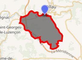 | |
) Creissels ) Creissels | |
| Coordinates: 44°05′16″N 3°03′57″E / 44.0878°N 3.0658°E | |
| Country | France |
| Region | Occitanie |
| Department | Aveyron |
| Arrondissement | Millau |
| Canton | Millau-1 |
| Intercommunality | Millau Grands Causses |
| Government | |
| • Mayor (2008–2014) | Thierry Terral |
| Area 1 | 28.19 km2 (10.88 sq mi) |
| Population (Jan. 2017)[1] | 1,591 |
| • Density | 56/km2 (150/sq mi) |
| Time zone | UTC+01:00 (CET) |
| • Summer (DST) | UTC+02:00 (CEST) |
| INSEE/Postal code | 084 12 084 /12 100 |
| Elevation | 340–808 m (1,115–2,651 ft) (avg. 438 m or 1,437 ft) |
| 1 French Land Register data, which excludes lakes, ponds, glaciers > 1 km2 (0.386 sq mi or 247 acres) and river estuaries. | |
Creissels is a commune in the Aveyron department in southern France.
Population
| Year | Pop. | ±% |
|---|---|---|
| 1793 | 420 | — |
| 1800 | 493 | +17.4% |
| 1806 | 296 | −40.0% |
| 1821 | 644 | +117.6% |
| 1831 | 654 | +1.6% |
| 1836 | 651 | −0.5% |
| 1841 | 637 | −2.2% |
| 1846 | 668 | +4.9% |
| 1851 | 693 | +3.7% |
| 1856 | 642 | −7.4% |
| 1861 | 700 | +9.0% |
| 1866 | 714 | +2.0% |
| 1872 | 730 | +2.2% |
| 1876 | 800 | +9.6% |
| 1881 | 752 | −6.0% |
| 1886 | 734 | −2.4% |
| 1891 | 695 | −5.3% |
| 1896 | 730 | +5.0% |
| 1901 | 790 | +8.2% |
| 1906 | 778 | −1.5% |
| 1911 | 724 | −6.9% |
| 1921 | 651 | −10.1% |
| 1926 | 655 | +0.6% |
| 1931 | 625 | −4.6% |
| 1936 | 581 | −7.0% |
| 1946 | 611 | +5.2% |
| 1954 | 725 | +18.7% |
| 1962 | 837 | +15.4% |
| 1968 | 936 | +11.8% |
| 1975 | 1,291 | +37.9% |
| 1982 | 1,326 | +2.7% |
| 1990 | 1,401 | +5.7% |
| 1999 | 1,501 | +7.1% |
| 2008 | 1,486 | −1.0% |
See also
- Millau Viaduct
- Communes of the Aveyron department
References
- ^ "Populations légales 2017". INSEE. Retrieved 6 January 2020.