| Cheselbourne | |
|---|---|
_-_geograph.org.uk_-_887187.jpg) Parish Church of St Martin | |
Location within Dorset | |
| Population | 296 [1] |
| OS grid reference | SY763997 |
| Unitary authority |
|
| Shire county | |
| Region | |
| Country | England |
| Sovereign state | United Kingdom |
| Post town | Dorchester |
| Postcode district | DT2 |
| Police | Dorset |
| Fire | Dorset and Wiltshire |
| Ambulance | South Western |
| UK Parliament | |
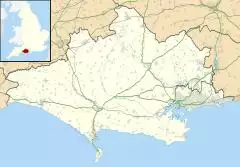
Cheselbourne (sometimes spelled Chesilborne[2] or Cheselborne) is a village and civil parish in Dorset, England, situated in the Dorset Downs, 7 miles (11 km) north-east of Dorchester. The parish is at an altitude of 75 to 245 metres (approximately 250 to 800 feet) and covers an area of 1,175 hectares (2,900 acres); the underlying geology is chalk.[3] In the 2011 census the parish had a population of 296.[1]
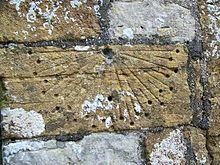
The village, which contains a mix of buildings of different ages and styles, is spread along four lanes which meet here. It has a public house called the Rivers Arms. The 13th- to 14th-century parish church has a pinnacled tower with battlements, numerous gargoyles[4] and a canonical sundial.
In 1086, in the Domesday Book Cheselbourne was recorded as Ceseburne;[5] it had 36 households, 10 acres (4.0 ha) of meadow and one mill. It was in the hundred of Hilton and the lord and tenant-in-chief was Shaftesbury Abbey.[6]
Cheselbourne used to be the site of a tradition known as "Treading in the Wheat", in which young women from the village would walk the fields on Palm Sunday, dressed in white.[4]
At Lyscombe Farm in the northwest of the parish are the remains of an early 13th-century chapel. The nave was once used as a bakehouse and then a farmworker's dwelling. In 1957, a Dutch barn was built over the ruins.[4]
References
- ^ a b "Area: Cheselbourne (Parish). Key Figures for 2011 Census: Key Statistics". Neighbourhood Statistics. Office for National Statistics. Retrieved 20 January 2014.
- ^ Ralph Wightman (1983). Portrait of Dorset (4 ed.). Robert Hale Ltd. pp. 107–8. ISBN 0 7090 0844 9.
- ^ "'Cheselbourne', An Inventory of the Historical Monuments in Dorset, Volume 3: Central (1970), pp. 73-79". British History Online. University of London & History of Parliament Trust. November 2013. Retrieved 8 June 2014.
- ^ a b c Roland Gant (1980). Dorset Villages. Robert Hale Ltd. pp. 88–9. ISBN 0 7091 8135 3.
- ^ "Dorset A-G". The Domesday Book Online. domesdaybook.co.uk. Retrieved 27 February 2015.
- ^ "Place: Cheselbourne". Open Domesday. domesdaymap.co.uk. Archived from the original on 2 April 2015. Retrieved 27 February 2015.
External links

