| Cerro Solo | |
|---|---|
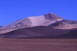
 Cerro Solo from the North | |
| Highest point | |
| Elevation | 6,205 m (20,358 ft) [1] |
| Coordinates | 27°06′30″S 68°43′0″W / 27.10833°S 68.71667°W |
| Geography | |
| Location | Argentina-Chile |
| Parent range | Andes |
| Geology | |
| Mountain type | Stratovolcano |
| Last eruption | Unknown |
| Climbing | |
| First ascent | 1949 |
| Easiest route | Hike |
Cerro Solo is a large stratovolcano on the border between Argentina and Chile, west of Ojos del Salado. It consists of nine eruptive centers and is covered in light-colored rhyodacite pyroclastic flow deposits.
See also
References
- ^ Biggar, John (2020). The Andes - A Guide for Climbers and Skiers (5th ed.). Scotland: Andes. p. 330. ISBN 978-0-9536087-6-8.
- "El Solo". Global Volcanism Program. Smithsonian Institution.