Callantsoog | |
|---|---|
Town | |
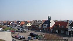
 View on Callantsoog. | |
 | |
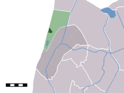
 The town centre (darkgreen) and the statistical district (lightgreen) of Callantsoog in the former municipality of Zijpe. | |
| Coordinates: 52°50′N 4°42′E / 52.833°N 4.700°E | |
| Country | Netherlands |
| Province | North Holland |
| Municipality | Schagen |
| Population | |
| • Total | 1,956 |
| Time zone | UTC+1 (CET) |
| • Summer (DST) | UTC+2 (CEST) |
Callantsoog (West Frisian: Kallantsouge) is a town in the Dutch province of North Holland. It is a part of the municipality of Schagen, and lies about 18 km south of Den Helder. Callantsoog was a separate municipality until 1990, when it was merged with Zijpe.[1] Since 1990, the area of Callantsoog had made part of the municipalities of Zijpe, Den Helder, and Anna Paulowna. In 2012, Anna Paulowna has become part of the new municipality of Hollands Kroon, and in 2013, Zijpe merged with Schagen into the new municipality of Schagen. For that reason the area of Callantsoog has made part of the municipalities of Schagen, Den Helder and Hollands Kroon since 2013.
Callantsoog has the oldest official nude beach of the country, dating from 1973. It is a sandy beach 1.5 kilometres (0.93 mi) to the south.[2]
In 2001, the town of Callantsoog had 1956 inhabitants. The built-up area of the town was 0.58 km², and contained 899 residences.[3] The wider statistical area "Callantsoog" has a population of around 2580.[4] This includes also the village of Groote Keeten and the hamlet of Abbestede north of Callantsoog itself.
References
- ^ Ad van der Meer and Onno Boonstra, Repertorium van Nederlandse gemeenten, KNAW, 2011.
- ^ "Nudist beach Callantsoog". naaktstrandje.nl. Retrieved 2016-03-06.
- ^ Statistics Netherlands (CBS), Bevolkingskernen in Nederland 2001 "Archived copy". Archived from the original on 2006-03-19. Retrieved 2007-01-24.. Statistics are for the continuous built-up area.
- ^ Statistics Netherlands (CBS), Gemeente Op Maat 2004: Zijpe [1].
External links
- J. Kuyper, Gemeente Atlas van Nederland, 1865-1870, "Callantsoog". Map of the former municipality, around 1868.
