Breuilpont | |
|---|---|
) The chapel in Breuilpont | |
.svg.gif')) Coat of arms | |
Location of Breuilpont 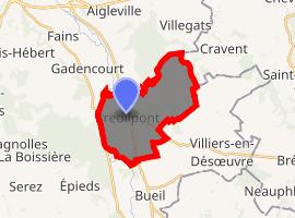 | |
) Breuilpont ) Breuilpont | |
| Coordinates: 48°57′50″N 1°25′38″E / 48.9639°N 1.4272°E | |
| Country | France |
| Region | Normandy |
| Department | Eure |
| Arrondissement | Les Andelys |
| Canton | Pacy-sur-Eure |
| Government | |
| • Mayor (2008–2014) | Joseph Placier |
| Area 1 | 12.21 km2 (4.71 sq mi) |
| Population (Jan. 2017)[1] | 1,222 |
| • Density | 100/km2 (260/sq mi) |
| Time zone | UTC+01:00 (CET) |
| • Summer (DST) | UTC+02:00 (CEST) |
| INSEE/Postal code | 27114 /27640 |
| Elevation | 46–137 m (151–449 ft) (avg. 46 m or 151 ft) |
| 1 French Land Register data, which excludes lakes, ponds, glaciers > 1 km2 (0.386 sq mi or 247 acres) and river estuaries. | |
Breuilpont is a commune in the Eure department in Normandy in northern France.
Population
| Year | Pop. | ±% |
|---|---|---|
| 1962 | 460 | — |
| 1968 | 512 | +11.3% |
| 1975 | 515 | +0.6% |
| 1982 | 592 | +15.0% |
| 1990 | 985 | +66.4% |
| 1999 | 1,111 | +12.8% |
| 2008 | 1,168 | +5.1% |
See also
References
- ^ "Populations légales 2017". INSEE. Retrieved 6 January 2020.
External links