Wikipedia

Bayfield Peninsula

The Bayfield Peninsula

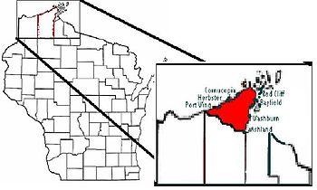
The Bayfield Peninsula is a peninsula on Lake Superior. It is located in Bayfield County, Wisconsin USA. It is the northernmost region of mainland Wisconsin, with the south shore of Lake Superior to the west and the Chequamegon Bay to the east. The peninsula is part of the Lake Superior Lowland, though the interior southeast of Cornucopia and west of Bayfield has some higher ground including Pratt's Peak, Bayfield County's second-highest point. Highway 13 runs around the peninsula along the Superior shoreline. The communities of Port Wing, Herbster, Cornucopia, Red Cliff, Bayfield, Washburn, and Ashland lie on this stretch of highway. The interior of the peninsula is mostly the northern end of the Chequamegon National Forest, an area of jackpine growth known as the Moquah Barrens. The Apostle Islands surround the end of the peninsula.[1][2]

Notes

This article is copied from an article on Wikipedia® - the free encyclopedia created and edited by its online user community. The text was not checked or edited by anyone on our staff. Although the vast majority of Wikipedia® encyclopedia articles provide accurate and timely information, please do not assume the accuracy of any particular article. This article is distributed under the terms of GNU Free Documentation License.

Copyright © 2003-2025 Farlex, Inc Disclaimer
All content on this website, including dictionary, thesaurus, literature, geography, and other reference data is for informational purposes only. This information should not be considered complete, up to date, and is not intended to be used in place of a visit, consultation, or advice of a legal, medical, or any other professional.