Bannur ಬನ್ನೂರು | |
|---|---|
Town | |
) | |
| Coordinates: 12°15′17″N 76°54′25″E / 12.2548°N 76.9070°E | |
| Country | |
| State | Karnataka |
| District | Mysore |
| Government | |
| • Type | Municipality |
| Elevation | 654 m (2,146 ft) |
| Population (2011) | |
| • Total | 21,896 |
| Language | |
| • Official | ಕನ್ನಡ (Kannada) |
| Time zone | UTC+5:30 (IST) |
| PIN | 571101 |
| ISO 3166 code | IN-KA |
| Vehicle registration | KA-09, KA-55 |
| Website | karnataka |
Bannur is a Municipality in Mysore district (ಮೈಸೂರು) in the state of Karnataka, India.[1]
Geography
Bannur is located at 12°20′N 76°52′E / 12.33°N 76.86°E.[2] It has an average elevation of 654 metres (2145 feet). T Narasipura Taluk Near Somanathapur Temple pin code 571101
Bannur temple
Bannur temple is located right opposite to the bus station. The temple car is decorated during festival times and dragged along the town in a procession of musicians and dancers. Thousands of people takes part in this festival which is conducted in February every year.
Demographics
As of 2011 Census, Bannur Town Municipal Council has population of 21,896 of which 10,849 are males while 11,047 are females as per report released by Census India 2011.
Population of Children with age of 0-6 is 2366 which is 10.81 % of total population of Bannur (TMC). In Bannur Town Municipal Council, Female Sex Ratio is of 1018 against state average of 973. Moreover Child Sex Ratio in Bannur is around 1040 compared to Karnataka state average of 948. Literacy rate of Bannur city is 70.75 % lower than state average of 75.36 %. In Bannur, Male literacy is around 74.85 % while female literacy rate is 66.72 %.
Bannur Town Municipal Council has total administration over 5,186 houses to which it supplies basic amenities like water and sewerage. It is also authorize to build roads within Town Municipal Council limits and impose taxes on properties coming under its jurisdiction.[3]
Image Gallery
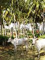
Coconut Farm
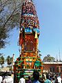
Decorated temple car
SRP Road
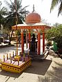
Ganesh Temple
)
)
)
)
See also
- Srirangapatna
- Arakere
- Karighatta Road
- Kodagahalli
- Somanathapura
- Mahadevapura
References
- ^ "Unauthorized Request Blocked". www.bannurtown.mrc.gov.in. Retrieved 30 June 2017.
- ^ "Maps, Weather, and Airports for Bannur, India". www.fallingrain.com. Retrieved 30 June 2017.
- ^ "Census 2011" (PDF).