Bolton | |
|---|---|
) BL | |
| Coordinates: 53°35′13″N 2°24′29″W / 53.587°N 2.408°W | |
| Country | United Kingdom |
| Postcode area | BL |
| Postcode area name | Bolton |
| Post towns | 2 |
| Postcode districts | 10 |
| Postcode sectors | 53 |
| Postcodes (live) | 10,285 |
| Postcodes (total) | 13,912 |
| Statistics as at May 2020[1] | |
The BL postcode area, also known as the Bolton postcode area,[2] is a group of ten postcode districts in North West England. These cover most of the Metropolitan Borough of Bolton and the northern and central parts of the Metropolitan Borough of Bury in Greater Manchester, plus small parts of the boroughs of Chorley, Rossendale and Blackburn with Darwen in Lancashire.
Coverage
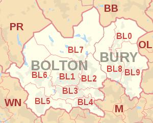
The approximate coverage of the postcode districts:
| Postcode district | Post town | Coverage | Local authority area(s) |
|---|---|---|---|
| BL0 | BURY | Ramsbottom, Edenfield, Shuttleworth | Bury, Rossendale |
| BL1 | BOLTON | Bolton centre, Smithills, Halliwell, Heaton | Bolton |
| BL2 | BOLTON | Bolton centre, Ainsworth, Bradley Fold, Bradshaw, Breightmet, Harwood, Tonge Fold, Tonge Moor | Bolton, Bury |
| BL3 | BOLTON | Bolton centre, Little Lever, Great Lever, Darcy Lever, Deane | Bolton |
| BL4 | BOLTON | Farnworth, Kearsley | Bolton |
| BL5 | BOLTON | Over Hulton, Westhoughton | Bolton |
| BL6 | BOLTON | Blackrod, Horwich, Lostock, Rivington | Bolton, Chorley |
| BL7 | BOLTON | Belmont, Bromley Cross, Chapeltown, Edgworth, Egerton, Turton | Blackburn with Darwen, Bolton |
| BL8 | BURY | Bury centre, Brandlesholme, Greenmount, Affetside, Hawkshaw, Holcombe, Ramsbottom, Tottington, Walshaw | Bury |
| BL9 | BURY | Bury centre, Heap, Heap Bridge, Nangreaves, Summerseat, Unsworth, Walmersley, Bircle, Jericho | Bury |
Map
See also
References
- ^ "ONS Postcode Directory Version Notes" (ZIP). National Statistics Postcode Products. Office for National Statistics. May 2020. Table 2. Retrieved 19 June 2020. Coordinates from mean of unit postcode points, "Code-Point Open". OS OpenData. Ordnance Survey. February 2012. Retrieved 21 April 2012.
- ^ Royal Mail, Address Management Guide, (2004)