| Asselby | |
|---|---|
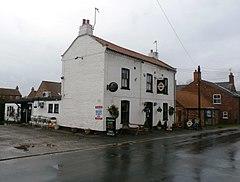
 The Black Swan | |
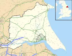
Location within the East Riding of Yorkshire | |
| Population | 351 (2011 census)[1] |
| OS grid reference | SE717280 |
| • London | 155 mi (249 km) S |
| Civil parish |
|
| Unitary authority | |
| Ceremonial county | |
| Region | |
| Country | England |
| Sovereign state | United Kingdom |
| Post town | GOOLE |
| Postcode district | DN14 |
| Dialling code | 01757 |
| Police | Humberside |
| Fire | Humberside |
| Ambulance | Yorkshire |
| UK Parliament | |
Asselby is a village and civil parish in the East Riding of Yorkshire, England. It is located in the south-west of the county, north of the River Ouse. It is situated approximately 2 miles (3.2 km) west of the market town of Howden. The land surrounding Asselby is very flat and intersected by dykes which drain into the Rivers Aire and Ouse.
The civil parish is formed by the village of Asselby and the hamlet of Knedlington, together with that part of Boothferry village west of the B1228 road. According to the 2011 UK census, Asselby parish had a population of 351,[1] a rise from the 2001 UK census figure of 299.[2] The parish covers an area of 532.14 hectares (1,314.9 acres).[3]
The Hull and Barnsley Railway ran past the village until 1955, having a level crossing named 'Asselby'. The closest station was Barmby railway station.
The village has one pub, The Black Swan, situated on Main Street. Unusually, Asselby is situated on an entirely dead-end road, which finishes in the next village (which is slightly larger than Asselby), Barmby on the Marsh.
Northern Gas Networks has a gas pressure reduction and odourisation plant just outside of Asselby.
References
- ^ a b UK Census (2011). "Local Area Report – Asselby Parish (1170211133)". Nomis. Office for National Statistics. Retrieved 14 February 2018.
- ^ UK Census (2001). "Local Area Report – Asselby Parish (1543504180)". Nomis. Office for National Statistics. Retrieved 23 November 2018.
- ^ "2001 Census Area Profile" (PDF). East Riding of Yorkshire Council. 2004. Archived from the original (PDF) on 10 September 2012. Retrieved 10 April 2013.
- Gazetteer — A–Z of Towns Villages and Hamlets. East Riding of Yorkshire Council. 2006. p. 3.
External links
- Asselby in the Domesday Book

