Apan | |
|---|---|
Municipality and city | |
) | |
) Glyph or Coat of arms | |
) Apan Location in Mexico | |
| Coordinates: 19°42′N 98°26′W / 19.700°N 98.433°W | |
| Country | |
| State | Hidalgo |
| Municipal seat | Apan |
| Area | |
| • Total | 346.9 km2 (133.9 sq mi) |
| Elevation | 2,468 m (8,097 ft) |
| Population (2005) | |
| • Total | 39,247 |
| Time zone | UTC-6 (CST) |
| • Summer (DST) | UTC-5 (CDT) |
Apan is a city and one of the 84 municipalities of Hidalgo, in central-eastern Mexico. The municipality covers an area of 346.9 km².
Overview
As of 2005, the municipality had a total population of 39,247.[1]
It was an important site in the War of Independence (1810-1821). It is a center for the production of pulque and for the sport of charrería, or Mexican rodeo .
Notable people from Apan
- Heriberto Lazcano Lazcano, Mexican drug lord and the leader of Los Zetas Cartel
Gallery
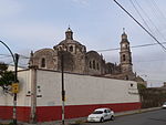
Church
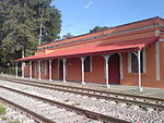
Railway station
)
)
References
- ^ "Apan". Enciclopedia de los Municipios de México. Instituto Nacional para el Federalismo y el Desarrollo Municipal. Archived from the original on November 29, 2006. Retrieved December 27, 2008.
External links
![]() Media related to Apan Municipality at Wikimedia Commons
Media related to Apan Municipality at Wikimedia Commons