Wikipedia

Alor Strait

Alor Strait
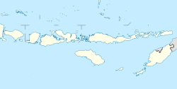
Alor Strait is located in Lesser Sunda Islands
Alor Strait
Alor Strait
Coordinates8°20′00″S 123°48′00″E / 8.33333°S 123.80000°E
Typestrait
Native nameIndonesian: Selat Alor
Basin countriesIndonesia
ReferencesSelat Alor: Indonesia National Geospatial-Intelligence Agency, Bethesda, MD, USA

Alor Strait (also Alloo Strait[1]) divides the Solor Archipelago from the Alor Archipelago, in the Lesser Sunda Islands of Indonesia. It lies mainly between the larger islands of Pantar and Lembata. The strait connects the western part of the Banda Sea in the north to the Savu Sea in the south.

Notes

  1. ^ Goodall, George (Editor)(1943) Philips' International Atlas London, George Philip and Son map 'East Indies' pp.91-92 for pre Independence spelling
This article is copied from an article on Wikipedia® - the free encyclopedia created and edited by its online user community. The text was not checked or edited by anyone on our staff. Although the vast majority of Wikipedia® encyclopedia articles provide accurate and timely information, please do not assume the accuracy of any particular article. This article is distributed under the terms of GNU Free Documentation License.

Copyright © 2003-2025 Farlex, Inc Disclaimer
All content on this website, including dictionary, thesaurus, literature, geography, and other reference data is for informational purposes only. This information should not be considered complete, up to date, and is not intended to be used in place of a visit, consultation, or advice of a legal, medical, or any other professional.