Algodonales | |
|---|---|
) | |
) Flag ) Coat of arms | |
.jpg')) | |
) Algodonales Location in Spain | |
| Coordinates: 36°52′52″N 5°24′20″W / 36.88111°N 5.40556°W | |
| Country | |
| Autonomous community | Andalusia |
| Province | Cádiz |
| Comarca | Sierra de Cádiz |
| Government | |
| • Alcalde | Antonio Acuña Racero (2012) (PSOE) |
| Area | |
| • Total | 134.16 km2 (51.80 sq mi) |
| Elevation | 370 m (1,210 ft) |
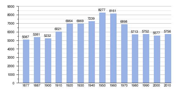
| Population (2018)[1] | |
| • Total | 5,590 |
| • Density | 42/km2 (110/sq mi) |
| Demonym(s) | Algodonaleño, ña |
| Time zone | UTC+1 (CET) |
| • Summer (DST) | UTC+2 (CEST) |
| Postal code | 11680 |
| Website | algodonales.es |
Algodonales is a city located in the province of Cádiz, Spain. According to the 2002 census, the city has a population of 5,607 inhabitants. The nearest cities are Zahara de la Sierra and Olvera. Algodonales is located in the Sierra de Lijar within the Sierra de Grazalema.
Demographics
Economy
- Agriculture
- Rural tourism
- Adventure travel
- guitar manufacturers
Monuments
- Ermita de la Concepción. (hermitage)
- Ermita de la Virgencita. (hermitage)
- Iglesia Parroquial de Santa Ana. (church)
References
- ^ Municipal Register of Spain 2018. National Statistics Institute.
External links
- Ayuntamiento de Algodonales
- Algodonales on Andalucia.com
- Algodonales on Turespaña
- Algodonales on Cadiz Tourism