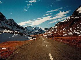
| Albula Pass | |
|---|---|
 Albula Pass road | |
| Elevation | 2,315 m (7,595 ft) |
| Traversed by | Road |
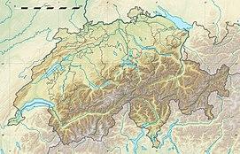
| Location | Graubünden, Switzerland |
| Range | Alps |
| Coordinates | 46°35′N 09°53′E / 46.583°N 9.883°E |
Albula Pass (Romansh: Pass d'Alvra[1] or ,[2] German: Albulapass) (el. 2315 m) is a Swiss mountain pass in the canton of Graubünden. It lies in the Albula Alps, on the watershed between the Albula, tributary of the Rhine and the Ova d'Alvra, tributary of the Inn. The road from Thusis through Bergün leads to La Punt in the Inn Valley (Engadin).
East of the pass, on the Engadin side, is a lake named Albulasee (2,294 m) which is 4.2 ha large.[3]
See also
- List of highest paved roads in Europe
- List of mountain passes
- List of the highest Swiss passes
References
- ^ Swisstopo maps, official maps of Switzerland by the Swiss government
- ^ "Pass da l'Alvra in the Pledari Grond dictionary". Archived from the original on 2011-07-07. Retrieved 2008-07-24.
- ^ Area retrieved from Google Earth (December 2014)
External links
- Profile on climbbybike.com
- Albula Pass in Romansh, German, French and Italian in the online Historical Dictionary of Switzerland.
- http://www.alpentourer.com/alpine_passes/switzerland/albulapass/albulapass.html

