| ||||
|---|---|---|---|---|
 | ||||
| Route information | ||||
| Maintained by ALDOT | ||||
| Length | 61.591 mi[1] (99.121 km) | |||
| Major junctions | ||||
| West end | ||||
| East end | ||||
| Location | ||||
| Counties | Lamar, Fayette, Walker | |||
| Highway system | ||||
| ||||
)
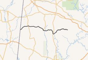
State Route 18 (SR 18) is a 61.591-mile-long (99.121 km) state highway in northwest Alabama.
Route description
SR 18 begins at the Mississippi state line near Vernon. In Vernon, it junctions with SR 17. It continues on its curvy route east, then southeast to the Fayette County line.
It then junctions with SR 107. It turns south and junctions with SR 96 west. It then junctions with US 43 north and SR 171. It continues southeast with US 43 south. It makes an unusual curve south in Stough. It turns east again and junctions with SR 13. SR 13 continues north independently and continues south with US 43 at this junction. It does not maintain a concurrency past this point. The route passes through Berry and maintains a concurrency with CR 63. After this concurrency ends, SR 18 continues east on its own route. It passes through hilly terrain and crosses into Walker County.
After continuing through hilly terrain for multiple more miles, the route ends in Oakman, just south of Jasper, at SR 69. SR 69 continues north on SR 18's right-of-way at this point and continues south at a new right-of-way.
Major intersections
| County | Location | mi[1] | km | Destinations | Notes |
|---|---|---|---|---|---|
| Lamar | | 0.00 | 0.00 | Mississippi state line | |
| Vernon | 9.84 | 15.84 | |||
| Fayette | | 24.31 | 39.12 | Southern terminus of SR 107 | |
| Fayette | 27.71 | 44.59 | Eastern terminus of SR 96 | ||
| 28.61 | 46.04 | Western end of US 43 concurrency | |||
| | 42.10 | 67.75 | Eastern end of US 43 concurrency | ||
| Walker | | 61.59 | 99.12 | Eastern terminus | |
1.000 mi = 1.609 km; 1.000 km = 0.621 mi
| |||||
References
- ^ a b "Mileposts/General Highway Maps". Alabama Department of Transportation. Archived from the original on July 27, 2011. Retrieved August 26, 2011.
External links