| 2003 Okanagan Mountain Park fire | |
|---|---|
 | |
| Location | Okanagan Mountain Park |
| Statistics | |
| Date(s) | August 16, 2003 |
| Burned area | 25,912 hectares (64,030 acres)[1] |
| Cause | lightning strike |
| Land use | Parkland, Rural |
| Buildings destroyed | 239 |
| Non-fatal injuries | water bomber crash |
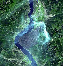
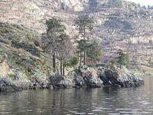
On August 16, 2003, at about 4 a.m., a wildfire was started by a lightning strike near Rattlesnake Island in Okanagan Mountain Provincial Park in British Columbia, Canada. The wildfire was fuelled by a constant wind and the driest summer on record up to that time.[2] Within a few days it had grown into a true firestorm.
The fire grew northward and eastward, initially threatening a small number of lakeshore homes, but quickly became an interface zone fire and forced the evacuation of 27,000 residents and consumed 239 homes. The final size of the firestorm was over 250 square kilometers (25,912 hectares (64,030 acres)).[1] Most of the trees in Okanagan Mountain Park were burned, and the park was closed.
60 fire departments, 1,400 armed forces troops and 1,000 forest fire fighters took part in controlling the fire, but were largely incapable of stopping the disaster.
There were also at least three private Canadair CL-215s, four Government of Alberta owned Canadair CL-215s, four private Lockheed L188 Electra air tankers and at least one Martin Mars air tanker attempting to put out the fire.
Amateur radio operators helped pass emergency traffic during this emergency. That cost was estimated at CAD $33.8 million.[1]
Castanet News released an article to commemorate the 14th anniversary of the fire:[3]
It was 14 years ago today that a lightning strike in the early morning hours of Aug. 16, just outside the southern boundaries of the city, across the lake from Peachland, sparked what would become, at the time, the largest post-war mass evacuation Canada had seen. It also led to the destruction of 239 homes in the Upper Mission, most of those in the Kettle Valley and Crawford Estates areas. Twelve wooden and two metal trestles in historic Myra Canyon were also damaged or destroyed. More than 33,000 people were evacuated; 4,000 of those were sent packing a second time as fires raged around them. At one point, it seemed people within the city were either out of their home, or hosting someone who was. The army was sent in to help battle the fires, setting up a makeshift camp on the Apple Bowl and Parkinson Rec Centre fields. At the height of the blaze, which burned through 26,500 hectares, firefighters on the front lines estimated the wall of flame to be up to 400 metres high. It was classified as a Rank 6 firestorm. On Sept. 12, all remaining evacuation alerts were lifted, and eight days later, the Ministry of Forests announced the fire was 100 per cent contained.
— Wayne Moore, Castanet.net
Links to news articles
See also
- Operation Peregrine
- List of fires in Canada
- List of disasters in Canada
References
- ^ a b c "Fire Review Summary for Okanagan Mountain Fire (K50628)" (PDF). BC Wildfire. Government of British Columbia. Retrieved 8 May 2016.
- ^ "BC's Year of Disastrous Weather - fires, floods and freezes". Environment Canada. Government of Canada. Retrieved 8 August 2017.
- ^ "Firestorm: 14 years later - Kelowna News". Castanet.net. Retrieved 21 January 2018.
- ^ "The Okanagan Mountain Park forest fire: Ten years later". CBC.ca. Retrieved 21 January 2018.
- ^ "10 years later: Remembering the Okanagan Mountain Park fire (Gallery)". GlobalNews.ca. Retrieved 21 January 2018.
- ^ PROCAYLO, ,NICK. "Okanagan Mountain Park fire, then and now". TheProvince.com. Retrieved 21 January 2018.
- ^ "okanagan mountain park fire - Google Search". www.Google.ca. Retrieved 21 January 2018.
External links
- "Okanagan Mountain fire: house sites aftermath". Retrieved 14 January 2009. Photographs of housing sites a few weeks after the fire, in September and October, 2003. Dr. Denis Wall Copyright.
- "Okanagan Mountain Fire Watch". Castanet.net. Archived from the original on 20 September 2005. Retrieved September 30, 2005. – Firewatch page set up for local residents during the fire (has many photos)
- NASA/JPL satellite image of fires in Northwestern North America August 21, 2003 (1800x1500px)
