Wikipedia

Woodthorpe, Nottinghamshire

Woodthorpe
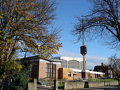
An Art Deco church of brick and concrete construction with a detached spire-cum-bell tower
Church of the Good Shepherd,
Thackerays Lane
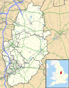
Woodthorpe is located in Nottinghamshire
Woodthorpe
Woodthorpe
Location within Nottinghamshire
OS grid referenceSK 58189 44238
District
  • Gedling
Shire county
Region
CountryEngland
Sovereign stateUnited Kingdom
Post townNOTTINGHAM
Postcode districtNG5, NG3
Dialling code0115
PoliceNottinghamshire
FireNottinghamshire
AmbulanceEast Midlands
UK Parliament

Woodthorpe is part of the Borough of Gedling and lies next to the city boundary. It is next to the areas of Mapperley, Daybrook, Sherwood and the main Arnold area.

Woodthorpe is characterized by a variety of different buildings from differentiate eras. It includes three schools, is home to two day nurseries and has two play/grassy parks. Shops are limited and most residents travel to nearby areas of Mapperley, Daybrook or Sherwood for local shopping..
References

This article is copied from an article on Wikipedia® - the free encyclopedia created and edited by its online user community. The text was not checked or edited by anyone on our staff. Although the vast majority of Wikipedia® encyclopedia articles provide accurate and timely information, please do not assume the accuracy of any particular article. This article is distributed under the terms of GNU Free Documentation License.

Copyright © 2003-2025 Farlex, Inc Disclaimer
All content on this website, including dictionary, thesaurus, literature, geography, and other reference data is for informational purposes only. This information should not be considered complete, up to date, and is not intended to be used in place of a visit, consultation, or advice of a legal, medical, or any other professional.