Wallerstein | |
|---|---|
) Von Jan House | |
Coat of arms  | |
Location of Wallerstein within Donau-Ries district ) | |
) Wallerstein ) Wallerstein | |
| Coordinates: 48°53′N 10°26′E / 48.883°N 10.433°E | |
| Country | Germany |
| State | Bavaria |
| Admin. region | Schwaben |
| District | Donau-Ries |
| Government | |
| • Mayor | Joseph Mayer (PW) |
| Area | |
| • Total | 19.45 km2 (7.51 sq mi) |
| Elevation | 441 m (1,447 ft) |
| Population (2019-12-31)[1] | |
| • Total | 3,390 |
| • Density | 170/km2 (450/sq mi) |
| Time zone | UTC+01:00 (CET) |
| • Summer (DST) | UTC+02:00 (CEST) |
| Postal codes | 86757 |
| Dialling codes | 09081 |
| Vehicle registration | DON |
| Website | www.markt-wallerstein.de |
Wallerstein is a municipality and former principality in the district of Donau-Ries in Bavaria in Germany.
It was first mentioned in 1238 as Steinheim. For generations ruled by the House of Oettingen-Wallerstein, in 1806 Wallerstein became part of the Kingdom of Bavaria by the process of mediatisation.
Mayors
- 1972-2002: Manfred Schürer
- since 2002: Joseph Mayer
Culture and Sights
- Castle Wallerstein
- Castle rock
- Old Jewish burial ground
- One of only three German Marian and Holy Trinity columns
Gallery
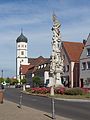
Wallerstein, monument (die Pestsäule) and Catholic Parish Church of Saint Alban

St. Oswald Church
)
)
Notable inhabitants
)
Ludwig, Prince of Oettingen-Wallerstein
- Louis of Oettingen-Wallerstein (1791-1870), Bavarian statesman and prince
- William Berczy (1744-1813), painter, colonist and architect, co-founder of Toronto
See also
- Synagogues of the Swabian type (Wallerstein)
References
- ^ "Tabellenblatt "Daten 2", Statistischer Bericht A1200C 202041 Einwohnerzahlen der Gemeinden, Kreise und Regierungsbezirke". Bayerisches Landesamt für Statistik und Datenverarbeitung (in German). July 2020.
Further reading
- Ludwig Brutscher: Wallerstein. Markt und Residenz. Beiträge zur Orts- und Grafschaftsgeschichte. Markt Wallerstein 1996.
External links
- Official website
 (in German)
 - "Wallerstein, Bavaria: History of the coat-of-arms" (in German). Haus der Bayerischen Geschichte.
- Amtliche Statistik (PDF; 1,3 MB)