Villers-Canivet | |
|---|---|
) The church in Villers-Canivet | |
.svg.gif')) Coat of arms | |
Location of Villers-Canivet 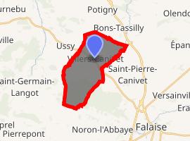 | |
) Villers-Canivet ) Villers-Canivet | |
| Coordinates: 48°56′28″N 0°15′15″W / 48.9411°N 0.2542°W | |
| Country | France |
| Region | Normandy |
| Department | Calvados |
| Arrondissement | Caen |
| Canton | Falaise |
| Intercommunality | Pays de Falaise |
| Government | |
| • Mayor (2008–2014) | Jean-Louis Bonne |
| Area 1 | 12.24 km2 (4.73 sq mi) |
| Population (Jan. 2017)[1] | 771 |
| • Density | 63/km2 (160/sq mi) |
| Time zone | UTC+01:00 (CET) |
| • Summer (DST) | UTC+02:00 (CEST) |
| INSEE/Postal code | 14753 /14420 |
| Elevation | 139–233 m (456–764 ft) (avg. 170 m or 560 ft) |
| 1 French Land Register data, which excludes lakes, ponds, glaciers > 1 km2 (0.386 sq mi or 247 acres) and river estuaries. | |
Villers-Canivet is a commune in the Calvados department in the Normandy region in northwestern France.
Population
| Year | Pop. | ±% |
|---|---|---|
| 1962 | 452 | — |
| 1968 | 460 | +1.8% |
| 1975 | 459 | −0.2% |
| 1982 | 476 | +3.7% |
| 1990 | 502 | +5.5% |
| 1999 | 497 | −1.0% |
| 2008 | 716 | +44.1% |
See also
References
- ^ "Populations légales 2017". INSEE. Retrieved 6 January 2020.