Vieux | |
|---|---|
) Roman ruins | |
Location of Vieux 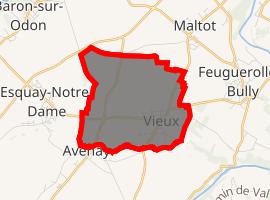 | |
) Vieux ) Vieux | |
| Coordinates: 49°06′30″N 0°25′57″W / 49.1083°N 0.4325°W | |
| Country | France |
| Region | Normandy |
| Department | Calvados |
| Arrondissement | Caen |
| Canton | Évrecy |
| Intercommunality | Évrecy-Orne-Odon |
| Government | |
| • Mayor (2020–2026) | Sophie Phelipeau |
| Area 1 | 5.50 km2 (2.12 sq mi) |
| Population (Jan. 2017)[1] | 686 |
| • Density | 120/km2 (320/sq mi) |
| Time zone | UTC+01:00 (CET) |
| • Summer (DST) | UTC+02:00 (CEST) |
| INSEE/Postal code | 14747 /14930 |
| Elevation | 25–112 m (82–367 ft) (avg. 93 m or 305 ft) |
| 1 French Land Register data, which excludes lakes, ponds, glaciers > 1 km2 (0.386 sq mi or 247 acres) and river estuaries. | |
Vieux (French pronunciation: [vjø] ) is a commune in the Calvados department in the Normandy region in northwestern France.
History
The town contains numerous Roman era ruins, as Vieux was a settlement called Aregenua, and appears on the Roman map, Tabula Peutingeriana.
During the Battle of Normandy in 1944, Vieux was designated as Hill 112 position, a strategic point for the Battle of Caen, the area of rue d'Esquay and the Bas de Vieux were badly affected by the allied bombardment of July 6, 1944. The portion of these streets, destroyed at this time are now dated for its name.
Sights
- The archaeological museum of Vieux-la-Romaine (as Aregenua, Vieux was capital of the Viducasses tribe).
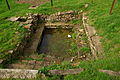
- Roman villa of Bas de Vieux

Le chemin Haussé.

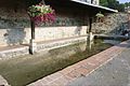
Lavoir de la place Saint-Martin
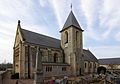
L'église Saint-Laurent.
Lavoir prés de church of Saint-Laurent.
Le lavoir romain des Mareaux.
)
)
)
)
)
Population
|
| ||||||||||||||||||||||||||||||||||||||||||||||||||||||||||||||||||||||||||||||||||||||||||||||||||||||||||||||||||
| Source: EHESS[2] and INSEE (1968-2017)[3] | |||||||||||||||||||||||||||||||||||||||||||||||||||||||||||||||||||||||||||||||||||||||||||||||||||||||||||||||||||
See also
References
- ^ "Populations légales 2017". INSEE. Retrieved 6 January 2020.
- ^ Des villages de Cassini aux communes d'aujourd'hui: Commune data sheet Vieux, EHESS. (in French)
- ^ Population en historique depuis 1968, INSEE
External links