Vieille-Église Oudekerke | |
|---|---|
_mairie.jpg')) The town hall of Vieille-Église | |
.svg.gif')) Coat of arms | |
Location of Vieille-Église 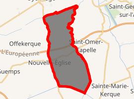 | |
) Vieille-Église ) Vieille-Église | |
| Coordinates: 50°55′45″N 2°04′39″E / 50.9292°N 02.0775°E | |
| Country | France |
| Region | Hauts-de-France |
| Department | Pas-de-Calais |
| Arrondissement | Calais |
| Canton | Marck |
| Intercommunality | Communauté de communes de la Région d'Audruicq |
| Government | |
| • Mayor (2020–2026) | Joël Levreay |
| Area 1 | 21.12 km2 (8.15 sq mi) |
| Population (Jan. 2017)[1] | 1,382 |
| • Density | 65/km2 (170/sq mi) |
| Time zone | UTC+01:00 (CET) |
| • Summer (DST) | UTC+02:00 (CEST) |
| INSEE/Postal code | 62852 /62162 |
| Elevation | 1–5 m (3.3–16.4 ft) (avg. 8 m or 26 ft) |
| 1 French Land Register data, which excludes lakes, ponds, glaciers > 1 km2 (0.386 sq mi or 247 acres) and river estuaries. | |
Vieille-Église (West Flemish: Oudekerke) is a commune in the Pas-de-Calais department in the Hauts-de-France region of France.
Geography
Vieille-Église is located 9 miles (15 km) east of Calais, at the D229 and D255 road junction, just a hundred yards from the A16 autoroute.
Population
| Year | 1962 | 1968 | 1975 | 1982 | 1990 | 1999 | 2006 |
|---|---|---|---|---|---|---|---|
| Population | 902 | 940 | 980 | 1003 | 968 | 1139 | 1241 |
| From the year 1962 on: No double counting—residents of multiple communes (e.g. students and military personnel) are counted only once. | |||||||
Places of interest
- The church of Saint Omer, dating from the nineteenth century.
See also
References
- ^ "Populations légales 2017". INSEE. Retrieved 6 January 2020.