| Ulúa River | |
|---|---|
 Ulúa river | |
| Location | |
| Country | Honduras |
| Physical characteristics | |
| Source | |
| • location | Intibucá, Honduras |
| Mouth | Caribbean Sea |
• location | Honduras |
• coordinates | 15°55′7″N 87°43′10″W / 15.91861°N 87.71944°W |
• elevation | 0 m (0 ft) |
| Basin size | 22,817 km2 (8,810 sq mi) |
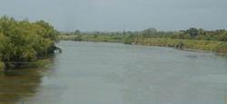
The Ulúa River (Spanish: Río Ulúa, Spanish pronunciation: [ˈri.o uˈlu.a]) is a river in western Honduras. It rises in the central mountainous area of the country close to La Paz and runs 240 kilometres (150 mi) approximately due northwards to the east end of the Gulf of Honduras at 15°55′N 87°43′W / 15.917°N 87.717°W. En route, it is joined by the Sulaco River, the Jicatuyo River, the Otoro River and the Chamelecón River. The Ulúa River valley is famed for its ornate calcite vessels that date from the Mayan times. One of them can be found in the British Museum's collection.[1]
References
