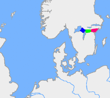
This is a map of the old border forests between Swedes and Geats.
Tylöskog is the
green region, the blue area is
Tiveden and the red is
KolmårdenTylöskog is a long and wide densely forested rocky ridge between the agricultural plains of the counties of Närke and Östergötland in southeast Sweden. Together with Tiveden to its west and Kolmården to its east, it constituted the border between the Swedes in Svealand and the Geats in Götaland in older times.
The name is derived from Tylö, a small locality in the forest; the suffix skog means forest in Swedish.
See also
External links
This article is copied from an
article on Wikipedia® - the free encyclopedia created and edited by its online user community. The text was not checked or edited by anyone on our staff. Although the vast majority of Wikipedia® encyclopedia articles provide accurate and timely information, please do not assume the accuracy of any particular article. This article is distributed under the terms of
GNU Free Documentation License.
All content on this website, including dictionary, thesaurus, literature, geography, and other reference data is for informational purposes only. This information should not be considered complete, up to date, and is not intended to be used in place of a visit, consultation, or advice of a legal, medical, or any other professional.
)