| Sign | Map |
|---|---|
) | ) |
| Area: | 40.65 km² |
| Inhabitants: | 113,140 (1999) |
| Population density: | 2783 inhabitants per km² |
| Politics | |
| Status: | Disestablished as borough with the 2001 administrative reform |
| Last mayor: | Siegfried Stock (SPD) |
Treptow (German pronunciation: [ˈtʁeːptoː]) is a former borough in the southeast of Berlin. It merged with Köpenick to form Treptow-Köpenick in 2001.
Geography
The district was composed by the localities of Alt-Treptow, Plänterwald, Baumschulenweg, Niederschöneweide, Johannisthal, Adlershof, Altglienicke and Bohnsdorf.
Photo gallery
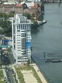
Twin Towers building in Treptow
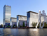
Treptowers compound in Treptow
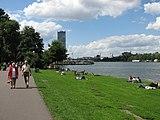
People sunbathing along the Spree River in Treptow
)
)
)
See also
- Alt-Treptow
External links
 Media related to Treptow at Wikimedia Commons
 Treptow travel guide from Wikivoyage