| Takase River | |
|---|---|
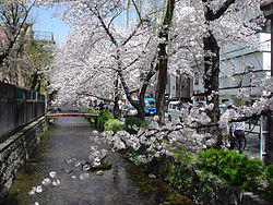
 The Takase River in central Kyoto | |
| Native name | 高瀬川 |
| Location | |
| Country | Japan |
| Physical characteristics | |
| Source | |
| • location | Kamo River |
| Mouth | |
• location | Uji River |
| Length | 9.7 km (6.0 mi) |
The Takase River (高瀬川, Takase-gawa) is a canal in Kyoto, Japan. It rises from Nijō-Kiyamachi, going along Kiyamachi Street, and meets the Uji River at Fushimi port. The canal crosses with the Kamo River on the way. Today the south half is not connected with Kamo River.
History
It was dug by Suminokura Ryōi in 1611, during the Edo period, to transport various goods and resources in the center of Kyoto. It made a great contribution to development of the city and economic growth at that time.
External links
35°00′44″N 135°46′12″E / 35.012329°N 135.769986°E (Takasegawa Ichino-Funairi, 高瀬川一之船入, Japanese national memorial, 1st port near Nijō-Kiyamachi)
34°58′23″N 135°45′52″E / 34.97319°N 135.764444°E (Takase River flows into Kamo River)
34°55′17″N 135°45′12″E / 34.921473°N 135.753458°E (Shin-Takase River flows into Uji River)