Wikipedia

Staunton Way

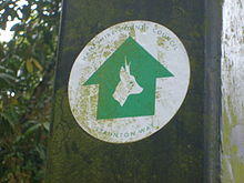
A Staunton Way waymarker.

The Staunton Way is a 20.5 mile recreational circular walk in Hampshire, southern England, that connects Queen Elizabeth Country Park to Staunton Country Park.

The route passes through the villages of Chalton, Finchdean and Rowlands Castle.

It is waymarked with the picture of a roe deer and a green arrow.

At Queen Elizabeth Country Park the walk connects to the South Downs Way and Hangers Way. At Rowland's Castle the path crosses the Monarch's Way. Sections of this walk also form part of the Sussex Border Path and Shipwrights Way. Originally a linear path extending to the coast, some sections have now been subsumed by, or shared with, the Shipwrights Way.

See also

External links

This article is copied from an article on Wikipedia® - the free encyclopedia created and edited by its online user community. The text was not checked or edited by anyone on our staff. Although the vast majority of Wikipedia® encyclopedia articles provide accurate and timely information, please do not assume the accuracy of any particular article. This article is distributed under the terms of GNU Free Documentation License.

Copyright © 2003-2025 Farlex, Inc Disclaimer
All content on this website, including dictionary, thesaurus, literature, geography, and other reference data is for informational purposes only. This information should not be considered complete, up to date, and is not intended to be used in place of a visit, consultation, or advice of a legal, medical, or any other professional.