Saint-Michel Eiheralarre | |
|---|---|
.jpg')) The church of Saint-Michel | |
) Coat of arms | |
Location of Saint-Michel 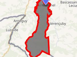 | |
) Saint-Michel ) Saint-Michel | |
| Coordinates: 43°08′13″N 1°13′12″W / 43.1369°N 1.2200°W | |
| Country | France |
| Region | Nouvelle-Aquitaine |
| Department | Pyrénées-Atlantiques |
| Arrondissement | Bayonne |
| Canton | Montagne Basque |
| Intercommunality | CA Pays Basque |
| Government | |
| • Mayor (2020–2026) | Raymond Minodo[1] |
| Area 1 | 30.30 km2 (11.70 sq mi) |
| Population (Jan. 2017)[2] | 295 |
| • Density | 9.7/km2 (25/sq mi) |
| Time zone | UTC+01:00 (CET) |
| • Summer (DST) | UTC+02:00 (CEST) |
| INSEE/Postal code | 64492 /64220 |
| Elevation | 177–1,417 m (581–4,649 ft) (avg. 255 m or 837 ft) |
| 1 French Land Register data, which excludes lakes, ponds, glaciers > 1 km2 (0.386 sq mi or 247 acres) and river estuaries. | |
Saint-Michel (Basque: Eiheralarre) is a commune in the Pyrénées-Atlantiques department in south-western France.
It is located in the former province of Lower Navarre. It borders Çaro to the north, Aincille and Estérençuby to the east, Uhart-Cize and Arnéguy to the west, and Spain to the south.
See also
References
- ^ "Répertoire national des élus: les maires". data.gouv.fr, Plateforme ouverte des données publiques françaises (in French). 2 December 2020. Retrieved 7 December 2020.
- ^ "Populations légales 2017". INSEE. Retrieved 6 January 2020.
External links
- EIHERALARRE in the Bernardo Estornés Lasa - Auñamendi Encyclopedia (Euskomedia Fundazioa) (in Spanish)
- Syndicat Mixte du Contrat de Rivière des Nives (in French)