Saint-Denis | |
|---|---|
) Slate siding | |
.svg.gif')) Coat of arms | |
Location of Saint-Denis 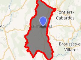 | |
) Saint-Denis ) Saint-Denis | |
| Coordinates: 43°21′39″N 2°13′18″E / 43.3608°N 2.2217°E | |
| Country | France |
| Region | Occitanie |
| Department | Aude |
| Arrondissement | Carcassonne |
| Canton | La Malepère à la Montagne Noire |
| Government | |
| • Mayor (2008–2014) | Raymond Sentenac |
| Area 1 | 8.21 km2 (3.17 sq mi) |
| Population (Jan. 2017)[1] | 512 |
| • Density | 62/km2 (160/sq mi) |
| Time zone | UTC+01:00 (CET) |
| • Summer (DST) | UTC+02:00 (CEST) |
| INSEE/Postal code | 11339 /11310 |
| Elevation | 280–645 m (919–2,116 ft) (avg. 528 m or 1,732 ft) |
| 1 French Land Register data, which excludes lakes, ponds, glaciers > 1 km2 (0.386 sq mi or 247 acres) and river estuaries. | |
Saint-Denis (Languedocien: Sant Danís) is a commune in the Aude department in southern France.
Population
| Year | Pop. | ±% |
|---|---|---|
| 1962 | 245 | — |
| 1968 | 292 | +19.2% |
| 1975 | 276 | −5.5% |
| 1982 | 277 | +0.4% |
| 1990 | 313 | +13.0% |
| 1999 | 389 | +24.3% |
| 2008 | 465 | +19.5% |
See also
References
- ^ "Populations légales 2017". INSEE. Retrieved 6 January 2020.