Ruda | |
|---|---|
| Comune di Ruda | |
) | |
) Coat of arms | |
Location of Ruda 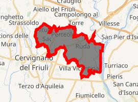 | |
) Ruda Location of Ruda in Italy ) Ruda Ruda (Friuli-Venezia Giulia) | |
| Coordinates: 45°50′N 13°24′E / 45.833°N 13.400°E | |
| Country | Italy |
| Region | Friuli-Venezia Giulia |
| Province | Udine (UD) |
| Frazioni | Alture, Cortona, Mortesins, Perteole, Saciletto, San Nicolò |
| Government | |
| • Mayor | Franco Lenarduzzi |
| Area | |
| • Total | 19.47 km2 (7.52 sq mi) |
| Elevation | 12 m (39 ft) |
| Population (28 February 2017)[3] | |
| • Total | 2,938 |
| • Density | 150/km2 (390/sq mi) |
| Demonym(s) | Rudesi |
| Time zone | UTC+1 (CET) |
| • Summer (DST) | UTC+2 (CEST) |
| Postal code | 33050 |
| Dialing code | 0431 |
| Patron saint | St. Stephen |
| Saint day | December 26 |
| Website | Official website |
Ruda (Friulian: Rude) is a comune (municipality) in the Province of Udine in the Italian region Friuli-Venezia Giulia, located about 40 kilometres (25 mi) northwest of Trieste and about 30 kilometres (19 mi) southeast of Udine.
Ruda borders the following municipalities: Aiello del Friuli, Campolongo al Torre, Cervignano del Friuli, Fiumicello Villa Vicentina, San Pier d'Isonzo, Turriaco, Villesse.
References
- ^ "Superficie di Comuni Province e Regioni italiane al 9 ottobre 2011". Istat. Retrieved 16 March 2019.
- ^ "Popolazione Residente al 1° Gennaio 2018". Istat. Retrieved 16 March 2019.
- ^ All demographics and other statistics: Italian statistical institute Istat.
External links