Rohrdorf | |
|---|---|
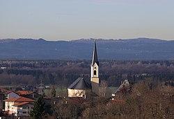
 Church of Saint James the Elder | |
| Coordinates: 47°47′56″N 12°10′3″E / 47.79889°N 12.16750°E | |
| Country | Germany |
| State | Bavaria |
| Admin. region | Oberbayern |
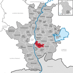
| District | Rosenheim |
| Subdivisions | 5 Ortsteile |
| Government | |
| • Mayor | Christian Praxl (CSU) |
| Area | |
| • Total | 28.67 km2 (11.07 sq mi) |
| Elevation | 476 m (1,562 ft) |
| Population (2019-12-31)[1] | |
| • Total | 5,853 |
| • Density | 200/km2 (530/sq mi) |
| Time zone | UTC+01:00 (CET) |
| • Summer (DST) | UTC+02:00 (CEST) |
| Postal codes | 83101 |
| Dialling codes | 08031, 08032 |
| Vehicle registration | RO |
| Website | www.rohrdorf.de |
Rohrdorf is a municipality in the district of Rosenheim in Upper Bavaria, Germany. It is located in the Inn valley.
History
Rohrdorf was first mentioned in 788 in the notitia arnonis.
Evidence of prehistoric settlement in the village has been found.
During World War II, a subcamp of Dachau concentration camp was located here.[2]
Twin towns
 Rosate, Italy
 Schattendorf, Austria
 Tarnowo Podgórne, Poland
References
- ^ "Tabellenblatt "Daten 2", Statistischer Bericht A1200C 202041 Einwohnerzahlen der Gemeinden, Kreise und Regierungsbezirke". Bayerisches Landesamt für Statistik und Datenverarbeitung (in German). July 2020.
- ^ "Archived copy". Archived from the original on 2009-02-09. Retrieved 2008-11-01.


