Rodrigues Alves, Acre | |
|---|---|
) | |
.svg.png')) Flag ) Seal | |
) Location of municipality in Acre State | |
) Rodrigues Alves, Acre Location in Brazil | |
| Coordinates: 07°44′31″S 72°38′49″W / 7.74194°S 72.64694°W | |
| Country | |
| State | Acre |
| Government | |
| • Mayor | Sebastiāo Correia (PMDB) |
| Area | |
| • Total | 1,276 sq mi (3,305 km2) |
| Population (2020 est [1]) | |
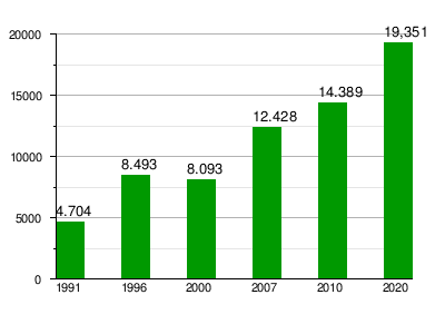
| • Total | 19,351 |
| Time zone | UTC-5 |
| Website | www |
Rodrigues Alves (Portuguese pronunciation: [ʁoˈdɾiɡiz‿ˈawvis]) is a municipality located in the west of the Brazilian state of Acre. Its population is 19,351 according to the 2020 estimates.
)
Conservation units in the west of the state of Acre, Brazil
The municipality contains 13.45% of the 846,633 hectares (2,092,080 acres) Serra do Divisor National Park, created in 1989.[2]
Population
References
- ^ IBGE 2020
- ^ PARNA da Serra do Divisor (in Portuguese), ISA: Instituto Socioambiental, retrieved 2016-08-08
External links