Wikipedia

River Keer

River Keer
Bend-in-Keer.jpg
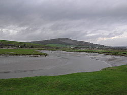
Bend in the Keer (with Warton Crag in the background) near Carnforth, Lancashire, England
Location
CountryUnited Kingdom
PartEngland
CountyLancashire, Cumbria

The River Keer is a river in Lancashire, England.

For parts of its course, the Keer marks the boundary between Lancashire and Cumbria, as well as the ancient counties of Lancashire and Westmorland.

The river rises on Docker Moor near the village of Whittington and follows a westerly course, passing the villages of Capernwray, Borwick and Warton, as well as Pine Lake, before reaching Carnforth, after which the river runs through salt marshes before pouring into the Kent estuary and Morecambe Bay.


This article is copied from an article on Wikipedia® - the free encyclopedia created and edited by its online user community. The text was not checked or edited by anyone on our staff. Although the vast majority of Wikipedia® encyclopedia articles provide accurate and timely information, please do not assume the accuracy of any particular article. This article is distributed under the terms of GNU Free Documentation License.

Copyright © 2003-2025 Farlex, Inc Disclaimer
All content on this website, including dictionary, thesaurus, literature, geography, and other reference data is for informational purposes only. This information should not be considered complete, up to date, and is not intended to be used in place of a visit, consultation, or advice of a legal, medical, or any other professional.