| |
|---|---|
| Route information | |
| Length | 36 km (22 mi) |
| Location | |
| Primary destinations | |
| Road network | |
| |
)
The R755 road is a regional road in Ireland. It runs for its entire length in County Wicklow. From the village of Kilmacanogue on the N11 national primary road it goes north/south for 36 km (22 mi) to the town of Rathdrum.
Route
From the N11 it goes west through the Rocky Valley and then turns south and rises sharply at the foot of the Sugar Loaf Mountain and crosses the Calary Bog to a junction with the eastern end of the Sally Gap road (R759) 3 km (1.9 mi) north of Roundwood village. It continues south through Roundwood and the hamlet of Annamoe to Laragh where it meets the Military Road and the Wicklow Gap Road. From Laragh it follows the Avonmore River for 12 km (7.5 mi) through dense conifer forests and oak woods before terminating in the town of Rathdrum at a junction with the R752.
Like the other main regional roads in the Wicklow Mountains, the R115, R759, R756, R752 and R747 this road passes through some wonderful scenery.
Photo gallery
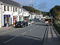
R755 passing through Roundwood
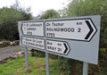
R755 road signs
)
)
See also
- Roads in Ireland
- National primary road
- National secondary road
- Clara, County Wicklow
References
- Roads Act 1993 (Classification of Regional Roads) Order 2006 – Department of Transport