Quirino | |
|---|---|
| Municipality of Quirino | |
) Seal | |
) Map of Ilocos Sur with Quirino highlighted | |
OpenStreetMap 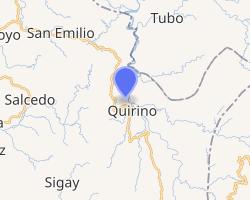 | |
.svg.gif')) Quirino Location within the Philippines | |
| Coordinates: 17°09′N 120°40′E / 17.15°N 120.67°E | |
| Country | |
| Region | Ilocos Region (Region I) |
| Province | Ilocos Sur |
| District | 2nd District |
| Named for | Elpidio Quirino |
| Barangays | 9 (see Barangays) |
| Government | |
| • Type | Sangguniang Bayan |
| • Mayor | Allen L. Nimo Jr. |
| • Vice Mayor | Rodolfo A. Aciong |
| • Representative | Kristine Singson-Meehan |
| • Electorate | 6,517 voters (2019) |
| Area | |
| • Total | 240.10 km2 (92.70 sq mi) |
| Elevation | 555 m (1,821 ft) |
| Population (2015 census) [3] | |
| • Total | 8,573 |
| • Density | 36/km2 (92/sq mi) |
| • Households | 1,824 |
| Economy | |
| • Income class | 4th municipal income class |
| • Poverty incidence | 20.35% (2015)[4] |
| • Revenue | ₱135,990,980.19 (2016) |
| Time zone | UTC+8 (PST) |
| ZIP code | 2721 |
| PSGC | |
| IDD : area code | +63 (0)77 |
| Climate type | tropical monsoon climate |
| Native languages | Kankanaey Ilocano Tagalog |
Quirino, officially the Municipality of Quirino (Ilocano: Ili ti Quirino; Filipino: Bayan ng Quirino), is a 4th class municipality in the province of Ilocos Sur, Philippines. According to the 2015 census, it has a population of 8,573 people. [3]
Formerly known as Angaki (also spelled Angkaki in some sources), the municipality was renamed in June 1964 to Quirino in honor of Elpidio Quirino, the sixth President of the Philippines.[5]
Barangays
Quirino is politically subdivided into 9 barangays. [2]
- Banoen
- Cayus
- Lamag (formerly Tubtuba)
- Legleg (Poblacion)
- Malideg
- Namitpit
- Patiacan
- Patungcaleo (formerly Lamag)
- Suagayan
Climate
| Climate data for Quirino, Ilocos Sur | |||||||||||||
|---|---|---|---|---|---|---|---|---|---|---|---|---|---|
| Month | Jan | Feb | Mar | Apr | May | Jun | Jul | Aug | Sep | Oct | Nov | Dec | Year |
| Average high °C (°F) | 28 (82) | 29 (84) | 31 (88) | 32 (90) | 30 (86) | 29 (84) | 28 (82) | 28 (82) | 28 (82) | 29 (84) | 29 (84) | 29 (84) | 29 (84) |
| Average low °C (°F) | 18 (64) | 19 (66) | 21 (70) | 23 (73) | 24 (75) | 24 (75) | 23 (73) | 23 (73) | 23 (73) | 21 (70) | 20 (68) | 19 (66) | 22 (71) |
| Average precipitation mm (inches) | 27 (1.1) | 31 (1.2) | 40 (1.6) | 71 (2.8) | 207 (8.1) | 237 (9.3) | 286 (11.3) | 261 (10.3) | 261 (10.3) | 254 (10.0) | 88 (3.5) | 46 (1.8) | 1,809 (71.3) |
| Average rainy days | 9.4 | 9.3 | 12.7 | 17.0 | 25.4 | 26.8 | 27.4 | 26.1 | 25.0 | 21.0 | 15.5 | 10.6 | 226.2 |
| Source: Meteoblue (modeled/calculated data, not measured locally)[6] | |||||||||||||
Demographics
| Year | Pop. | ±% p.a. |
|---|---|---|
| 1903 | 291 | — |
| 1918 | 2,817 | +16.34% |
| 1939 | 3,182 | +0.58% |
| 1948 | 3,130 | −0.18% |
| 1960 | 4,318 | +2.72% |
| 1970 | 5,539 | +2.52% |
| 1975 | 5,646 | +0.38% |
| 1980 | 5,283 | −1.32% |
| 1990 | 6,623 | +2.29% |
| 1995 | 7,295 | +1.83% |
| 2000 | 7,130 | −0.49% |
| 2007 | 7,866 | +1.36% |
| 2010 | 8,535 | +3.02% |
| 2015 | 8,573 | +0.08% |
| Source: Philippine Statistics Authority [3] [7] [8][9] | ||
In the 2015 census, the population of Quirino, Ilocos Sur, was 8,573 people, [3] with a density of 36 inhabitants per square kilometre or 93 inhabitants per square mile.
See also
- List of renamed cities and municipalities in the Philippines
References
- ^ Municipality of Quirino | (DILG)
- ^ a b "Province: Ilocos Sur". PSGC Interactive. Quezon City, Philippines: Philippine Statistics Authority. Retrieved 12 November 2016.
- ^ a b c d Census of Population (2015). "Region I (Ilocos Region)". Total Population by Province, City, Municipality and Barangay. PSA. Retrieved 20 June 2016.
- ^ "PSA releases the 2015 Municipal and City Level Poverty Estimates". Quezon City, Philippines. Retrieved 1 January 2020.
- ^ "REPUBLIC ACT NO. 4035 AN ACT CHANGING THE NAME OF THE MUNICIPALITY OF ANGAKI, PROVINCE OF ILOCOS SUR, TO QUIRINO". Philippine legal materials database. PhilippineLaw.info. June 18, 1964. Retrieved 20 September 2013.
- ^ "Quirino: Average Temperatures and Rainfall". Meteoblue. Retrieved 14 May 2020.
- ^ Census of Population and Housing (2010). "Region I (Ilocos Region)". Total Population by Province, City, Municipality and Barangay. NSO. Retrieved 29 June 2016.
- ^ Censuses of Population (1903–2007). "Region I (Ilocos Region)". Table 1. Population Enumerated in Various Censuses by Province/Highly Urbanized City: 1903 to 2007. NSO.
- ^ "Province of Ilocos Sur". Municipality Population Data. Local Water Utilities Administration Research Division. Retrieved 17 December 2016.
External links
- Quirino Profile at PhilAtlas.com
- Pasyalang Ilocos Sur
- Philippine Standard Geographic Code
- Philippine Census Information
- Local Governance Performance Management System