| Park Freeway | |
|---|---|
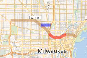 Canceled portions of Park Freeway highlighted in brown; demolished portion in red; canceled spur route in blue | |
| Route information | |
| Status | Demolished |
| Existed | 1969–2002[1] |
| Component highways | |
| Major junctions | |
| West end | |
| East end | Jefferson Street in Milwaukee[1] |
| Location | |
| Counties | Milwaukee |
| Highway system | |
| |
The Park Freeway was a freeway planned and partially constructed in Milwaukee, Wisconsin, United States. The freeway removal policy resulted in the demolition of the Park East Freeway, the only section to have been completed.
Route description
The planned eastern terminus of the Park Freeway in downtown Milwaukee was near Prospect Avenue and Ogden Avenue. At that point, the freeway was to turn southward as the Lake Freeway. The Park East Freeway, as built, extended from Jefferson Street westward to Interstate 43, carrying Highway 145.[1]
From I-43, the Park West Freeway was to continue northwesterly to just north of North Avenue. From there, it would continue westward to its intersection with the Stadium Freeway.[1]
History
The right of way for the entire Park Freeway was purchased and cleared. However, only a small portion was ever built - between North 12th Street and North Jefferson Street. Because of opposition of the freeway by community leaders, the remainder of the freeway was never built, and the right of way lay vacant for years. Much of the land has been redeveloped or designated as urban prairie parkland.
The only built portion was demolished beginning in 2002, most of which was replaced by an improved at-grade West McKinley Avenue and East Knapp Street and a new vertical-lift bridge over the Milwaukee River.
Redevelopment of the cleared freeway right-of-way was slowed by the economic recession that started in 2008. Milwaukee School of Engineering constructed an athletic facility.[2] Commercial developments include an ALOFT Hotel and offices.[3] The footprint of the freeway also contains the Fiserv Forum arena, the replacement for the Bradley Center, along with additional buildings, a practice facility, and entertainment properties encompassing the Milwaukee Bucks's Deer District.[4] Development has occurred on land adjacent to the former right-of-way, which is no longer overshadowed by the elevated freeway.[5]
References
- ^ a b c d e Bessert, Christopher J. "Milwaukee Freeways: Park Freeway". Wisconsin Highways. Retrieved August 29, 2020.
- ^ "Viets Field". Milwaukee School of Engineering.
- ^ Abele, Chris (March 21, 2016). "Jobs, Economic Development Springing Up in Park East" (Press release). Milwaukee County.
- ^ Daykin, Tom (October 4, 2016). "Zoning Panel Approves Clinic Near New Arena". Milwaukee Journal Sentinel.
- ^ "The North End". Mandel Group.
External links
- Wisconsin Highways: Milwaukee Freeways: Park Freeway, Christopher Bessert
- History of the Park East Freeway at Congress for the New Urbanism