| O'Malley Canberra, Australian Capital Territory | |||||||||||||||
|---|---|---|---|---|---|---|---|---|---|---|---|---|---|---|---|
) O'Malley | |||||||||||||||
| Coordinates | 35°21′09″S 149°06′31″E / 35.35250°S 149.10861°E | ||||||||||||||
| Population | 991 (2016 census)[1] | ||||||||||||||
| • Density | 381/km2 (987/sq mi) | ||||||||||||||
| Established | 1973 | ||||||||||||||
| Postcode(s) | 2606 | ||||||||||||||
| Area | 2.6 km2 (1.0 sq mi) | ||||||||||||||
| District | Woden Valley | ||||||||||||||
| Territory electorate(s) | Murrumbidgee | ||||||||||||||
| Federal Division(s) | Bean | ||||||||||||||
| |||||||||||||||
O'Malley (/ˈoʊmæli/) (postcode: 2606) is an affluent suburb of Canberra, Australian Capital Territory. At the 2016 census, O'Malley had a population of 991 people.[1] There are numerous embassies in O'Malley. In 2011, 42.8% of the population was foreign-born, the fifth-highest for any Canberra suburb.[2] The suburb is named after King O'Malley, who was the politician who arranged the competition for a design for Canberra. Streets in O'Malley are named with Aboriginal words.[3]
Population
In the 2016 Census, there were 991 people in O'Malley. 52.0% of people were born in Australia and 52.9% of people only spoke English at home. The most common responses for religion were Catholic 27.4% and No Religion 20.0%.[1]
Geology
Deakin Volcanics green-grey and purple rhyodacite are under the suburb. To the east in the valley bottom is Deakin Volcanics purple and green tuff and up the slopes of Mount Mugga Mugga are Deakin Volcanics coarse dark purple rhyodacite.[4]
Embassies
| Embassies and High Commissions in O'Malley | |||||
|---|---|---|---|---|---|
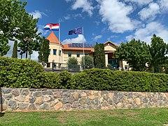
Embassy of Croatia in O'Malley
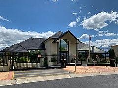
Military Attaché Office of the United Arab Emirates in O'Malley
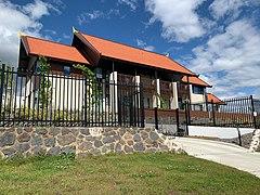
Embassy of Laos People's Democratic Republic in O'Malley
)
)
)
References
- ^ a b c Australian Bureau of Statistics (27 June 2017). "O'Malley (State Suburb)". 2016 Census QuickStats. Retrieved 30 June 2017.

- ^ "Where do migrants live? (4102.0 - Australian Social Trends, 2014)". Australian Bureau of Statistics. 17 March 2014. Retrieved 19 March 2014.
- ^ "Suburb Name search results". ACT Environment and Sustainable Development. Retrieved 4 February 2014.
- ^ Henderson, G. A. M.; Matveev, G. (1980). Geology of Canberra, Queanbeyan and Environs (Map). 1:50000.