Nishikan 西蒲区 | |
|---|---|
| Nishikan Ward | |
) Haza Tree in Nishikan-ku | |
) Location of Nishikan-ku in Niigata City | |
) Nishikan | |
| Coordinates: 37°45′37.8″N 138°53′21.6″E / 37.760500°N 138.889333°E | |
| Country | Japan |
| Region | Kōshin'etsu, Hokuriku (Chūbu) |
| Prefecture | Niigata |
| City | Niigata |
| Area | |
| • Total | 176.55 km2 (68.17 sq mi) |
| Population (September 1, 2016) | |
| • Total | 55,963 |
| • Density | 320/km2 (820/sq mi) |
| Time zone | UTC+9 (Japan Standard Time) |
| Address | 2690-1 Maki-kō, Nishikan-ku, Niigata-shi, Niigata 953-8666 |
| Phone number | 0256-73-1000 |
| Website | Official website |
)
Nishikan-ku (西蒲区, Nishikan-ku) is one of the eight wards of Niigata City, Niigata Prefecture, in the Hokuriku region of Japan. As of 1 June 2016, the ward had an estimated population of 55,963 in 20,369 households [1] and a population density of 320 persons per km². The total area of the ward was 176.55 square kilometres (68.17 sq mi).
Geography
Nishikan-ku is located in southwestern Niigata City, bordered by the Sea of Japan to the west. Mount Yahiko is on the border of Nishikan-ku with the neighbouring city of Nagaoka.
Surrounding municipalities
- Niigata Prefecture
History
The area of present-day Nishikan-ku was part of ancient Echigo Province. The town of Sone and the village of Iwamuro were established on April 1, 1889 within Nakakanbara District, Niigata with the establishment of the municipalities system. The town of Maki was created on April 10, 1891 by the merger of 14 hamlets, and expanded on January 1, 1955 by annexing five neighbouring villages. The town of Nishikawa was founded on January 1, 1955 by the merger of Sone with the village of Masugata. The city of Niigata annexed the towns of Maki and Masugata and the villages of Iwamuro, Katahigashi and Nakanokuchi on March 21, 2005. Niigata became a government-designated city on April 1, 2007 and was divided into wards, with the new Nishikan Ward consisting of these areas.
Education
Nishikan-ku has 13 public elementary schools and six public middle schools operated by the Niigata city government. The ward has three public high schools operated by the Niigata Prefectural Board of Education. The prefecture also operates two special education schools.
Transportation
Railway
![]() JR East - Echigo Line
JR East - Echigo Line
- Echigo-Sone - Maki - Iwamuro
Highways
.gif) Hokuriku Expressway
Hokuriku Expressway National Route 116
 National Route 402 (Seaside Line)
 National Route 460
Local attractions
)
- Iwamuro Onsen (hot spring) Resort
- Taho Onsen (hot spring)
- Mount Kakuda
- Uwasekigata Lagoon Park
- Maze Sea Circuit
- Gallery
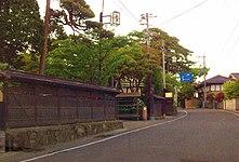
Iwamuro Onsen
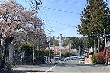
Hokkoku Kaidō and Taho Onsen
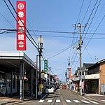
Maki shopping street
)
)
References
- ^ Niigata city official statisticsTemplate:Ja
External links
![]() Media related to Nishikan-ku, Niigata at Wikimedia Commons
Media related to Nishikan-ku, Niigata at Wikimedia Commons
- Niigata official website (in Japanese)
- Niigata Nishikan-ku website (in Japanese)
- Niigata City Official Tourist Information (multilingual)
- Niigata Pref. Official Travel Guide (multilingual)