Nagiso 南木曽町 | |
|---|---|
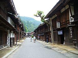
 Tsumagoe-juku in Nagiso | |
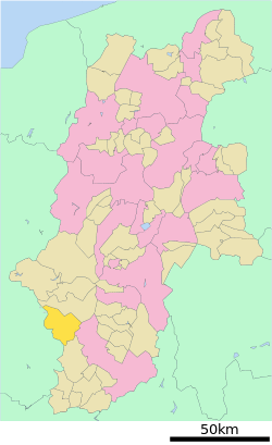
 Location of Nagiso in Nagano Prefecture | |
| Coordinates: 35°36′13.2″N 137°36′31.8″E / 35.603667°N 137.608833°E | |
| Country | Japan |
| Region | Chūbu (Kōshin'etsu) |
| Prefecture | Nagano |
| District | Kiso |
| Area | |
| • Total | 215.93 km2 (83.37 sq mi) |
| Population (April 2019) | |
| • Total | 4,111 |
| • Density | 19/km2 (49/sq mi) |
| Time zone | UTC+9 (Japan Standard Time) |
| Symbols | |
| • Tree | Chamaecyparis obtusa |
| • Flower | Rhododendron |
| Phone number | 0264-57-2001 |
| Address | 3668-1 Yomikaki, Nagiso-machi, Kiso-gun, Nagano-ken 399-5301 |
| Website | Official website |
Nagiso (南木曽町, Nagiso-machi) is a town located in Nagano Prefecture, Japan. As of 1 April 2019, the town had an estimated population of 4,111 in 1751 households,[1] and a population density of 19 persons per km². The total area of the town was 215.93 square kilometres (83.37 sq mi). Nagiso is listed as one of The Most Beautiful Villages in Japan.[2]
Geography
Nagiso is located in the Kiso Valley of southwestern Nagano Prefecture, bordered by Gifu Prefecture to the west. The Kiso River flows through the center of the town.
Surrounding municipalities
- Nagano Prefecture
- Gifu Prefecture
Demographics
Per Japanese census data,[3] the population of Nagiso has remained declined rapidly over the past 50 years.
| Year | Pop. | ±% |
|---|---|---|
| 1940 | 8,551 | — |
| 1950 | 10,258 | +20.0% |
| 1960 | 10,771 | +5.0% |
| 1970 | 8,020 | −25.5% |
| 1980 | 6,680 | −16.7% |
| 1990 | 6,142 | −8.1% |
| 2000 | 5,687 | −7.4% |
| 2010 | 4,810 | −15.4% |
Climate
The town has a climate characterized by characterized by hot and humid summers, and cold winters (Köppen climate classification Cfa). The average annual temperature in Nagiso is 12.8 °C. The average annual rainfall is 1786 mm with September as the wettest month. The temperatures are highest on average in August, at around 25.3 °C, and lowest in January, at around 0.7 °C.[4]
History
The area of present-day Nagiso was part of ancient Shinano Province. During the Edo period, the area developed as series of post stations on the Nakasendō highway connecting Edo with Kyoto. The villages of Yomikaki, Tsumagoi and Tadachi merged to form the town of Nagiso on May 1, 1968.
Education
Nagiso has one public elementary schools and one public middle school operated by the town government, and one high school operated the Nagano Prefectural Board of Education.
Transportation
Railway
.svg.png) JR Tōkai - Chūō Main Line
JR Tōkai - Chūō Main Line - Jūnikane - Nagiso - Tadachi
Highway
 National Route 19
 National Route 256
Local attractions
- Tsumago-juku
- Midono-juku
- Hidachi Falls, one of the 100 Famous Waterfalls of Japan
References
- ^ Nagiso Town official statistics(in Japanese)
- ^ The Most Beautiful Villages in Japan Archived 2015-02-15 at the Wayback Machine (in Japanese)
- ^ Nagiso population statistics
- ^ Nagiso climate data
External links
 Media related to Nagiso, Nagano at Wikimedia Commons
- Official Website (in Japanese)

