| Mount Baldy | |
|---|---|
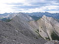
) Mount Baldy from over Barrier Lake | |
| Highest point | |
| Elevation | 2,192 m (7,192 ft) [1] |
| Prominence | 348 m (1,142 ft) [2] |
| Coordinates | 51°00′42″N 115°02′54″W / 51.01167°N 115.04833°W [2] |
| Geography | |
) Mount Baldy Location in Alberta | |
| Location | Alberta, Canada |
| Parent range | Fisher Range |
| Topo map | NTS 82O/03 |
| Climbing | |
| Easiest route | Easy scramble to North peak moderate to others. |
Mount Baldy is a mountain located in the Kananaskis River valley alongside Highway 40 in the Canadian Rockies.
During World War II, prisoners in a nearby internment camp were occasionally permitted to make the ascent of Mt. Baldy as long as they promised to return.[1] A University of Calgary research centre now occupies the former location of the camp.[2][3]
Up until 1984, when it was given its current day official name, it was commonly referred to as Barrier Mountain, due to its proximity to Barrier Lake.
Photos
South and west peaks from the summit of the north peak

View from Barrier Lake
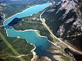
Towering over Barrier Lake
)
)
References
- ^ a b "Mount Baldy". PeakFinder.com. Retrieved 2019-08-20.
- ^ a b c "Mount Baldy". Bivouac.com. Retrieved 2008-12-25.
- ^ "Field Station Facilities". Biogeoscience Institute. University of Calgary. Retrieved 2008-12-25.
External links
- "Mount Baldy". Peakware.com. Archived from the original on 2016-03-04.
- Mount Baldy scramble description