Wikipedia

Mosquito Creek (Iowa)

Mosquito Creek
Nodaway-lewis.jpg
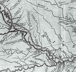
This excerpt from the Lewis and Clark map of 1814 shows the rivers of southwest Iowa, southeast Nebraska, and northwest Missouri. "Musquito River" is seen at the upper left.
Location
CountryUS
StateIowa
Physical characteristics
Source 
 • coordinates41°48′18″N 95°22′44″W / 41.805°N 95.379°W
Mouth 
 • coordinates
41°10′34″N 95°50′25″W / 41.176°N 95.8402°W

Mosquito Creek,[1] about 60 mi. (97 km) long, is a tributary of the Missouri River in southwest Iowa in the United States. It rises near Earling, in Shelby County, and flows in a generally southwesterly direction, meeting the Missouri approximately 5 mi. (8 km) downstream of Council Bluffs.

Mosquito Creek was named by pioneer settlers (Mormons) for the great number of mosquitoes near this stream when they camped there.[2]

See also

  • List of Iowa rivers

References

  1. ^ U.S. Geological Survey Geographic Names Information System: Mosquito Creek (Iowa)
  2. ^ History of Pottawattamie County, Iowa: Containing a History from the Earliest Settlement to the Present Time. O. L. Baskin & Company. 1883. p. 326.


This article is copied from an article on Wikipedia® - the free encyclopedia created and edited by its online user community. The text was not checked or edited by anyone on our staff. Although the vast majority of Wikipedia® encyclopedia articles provide accurate and timely information, please do not assume the accuracy of any particular article. This article is distributed under the terms of GNU Free Documentation License.

Copyright © 2003-2025 Farlex, Inc Disclaimer
All content on this website, including dictionary, thesaurus, literature, geography, and other reference data is for informational purposes only. This information should not be considered complete, up to date, and is not intended to be used in place of a visit, consultation, or advice of a legal, medical, or any other professional.