Montmélian | |
|---|---|
.jpg')) A view of Montmélian from the nearby hillside | |
) Flag ) Coat of arms | |
Location of Montmélian 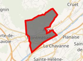 | |
) Montmélian ) Montmélian | |
| Coordinates: 45°30′12″N 6°03′15″E / 45.5033°N 6.0542°E | |
| Country | France |
| Region | Auvergne-Rhône-Alpes |
| Department | Savoie |
| Arrondissement | Chambéry |
| Canton | Montmélian |
| Government | |
| • Mayor (2020–2026) | Béatrice Santais (PS) |
| Area 1 | 5.69 km2 (2.20 sq mi) |
| Population (Jan. 2017)[1] | 4,123 |
| • Density | 720/km2 (1,900/sq mi) |
| Time zone | UTC+01:00 (CET) |
| • Summer (DST) | UTC+02:00 (CEST) |
| INSEE/Postal code | 73171 /73800 |
| Dialling codes | 0479 |
| Elevation | 256–1,200 m (840–3,937 ft) (avg. 285 m or 935 ft) |
| Website | www.montmelian.com |
| 1 French Land Register data, which excludes lakes, ponds, glaciers > 1 km2 (0.386 sq mi or 247 acres) and river estuaries. | |
Montmélian is a commune in the Savoie department in the Auvergne-Rhône-Alpes region in south-eastern France.
Population
|
| |||||||||||||||||||||||||||||||||||||||||||||||||||||||||||||||||||||||||||||||||||||||||||||||||||||||||
| Source: Ehess[2] and INSEE[3] | ||||||||||||||||||||||||||||||||||||||||||||||||||||||||||||||||||||||||||||||||||||||||||||||||||||||||||
See also
References
- ^ "Populations légales 2017". INSEE. Retrieved 6 January 2020.
- ^ Des villages de Cassini aux communes d'aujourd'hui: Commune data sheet Montmélian, EHESS. (in French)
- ^ INSEE: Population en historique depuis 1968
External links